Hiking the Mansard Trail: Kanab's Ancient Canvas
- Dan Wagner
- Oct 4, 2025
- 3 min read
The Mansard Trail in Kanab, Utah is one of the best hikes in Kanab for travelers seeking both scenery and history. This moderately challenging trail gains about 1,400 feet in elevation and offers incredible views of the Vermilion Cliffs and red rock landscapes that make Southern Utah famous. At the end of the hike, visitors are rewarded with a stunning alcove filled with ancient petroglyphs, making it one of the top petroglyph sites in the area. If you are looking for the best things to do in Kanab, hiking the Mansard Trail combines beautiful views, outdoor adventure, and Native American rock art in one unforgettable excursion.


Trailhead elevation 5,324'
Water none
Don't miss the hunt scene depiction
Hiking the Mansard Trail
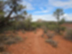
It’s my old man and me, on our second full day back in Kanab. He’s a little burned out from the last few days wandering around White Pocket, so I decide to head out for a late-afternoon hike and finally check out the Mansard Trail. The trailhead is just a ten-minute drive from town and I have a few hours before we head out to check out the Toadstool Hoodoos for sunset. I pull into the trailhead parking area beside a small residential subdivision and spot only two other vehicles. Maybe, just maybe, I’ll get some solitude.


I sling on my daypack and get moving. The path is easy to follow, passing quickly through a cattle gate before gently ascending along a compact sand trail.

Soon, the trail winds through the Vermillion Cliffs, climbing a long series of switchbacks framed by fragrant juniper and sagebrush. The incline isn’t steep, but the switchbacks seem endless. Still, the views of Kanab and the distant plateaus of northern Arizona make every step worth it.

Around the one-mile mark, the trail steepens, before an eight foot scramble over smooth Navajo sandstone slabs.

By around 1.4 miles, the trail evens out, heading north along the rim of the shallow canyon and revealing sweeping views of the White Cliffs ahead. After climbing nearly 1,200 feet to reach this point, the scenery feels like a well-earned reward.


A quarter mile later, I’m stepping through soft sand—not deep, but enough to slow my pace. Half a mile beyond, the path veers west and gently climbs again, leading to a deep, sandy 4x4 road skirting the southern edge of Mansard Mesa.

I follow the road uphill a short distance, avoiding the hiking trail to the left, until reaching a small turnaround.

From there, a trail branches off to the right and follows the base of a cliff for a few hundred feet before reaching a massive alcove.

Spread across the sloped sandstone floor are dozens—perhaps hundreds—of petroglyphs. Most are attributed to the Pueblo II period, roughly AD 950 to 1150, and the variety is striking: a hunt scene, bird tracks, concentric circles, shamans, bear prints,, snakes, human footprints, baskets, and more. Typical depictions found throughout the Southwest, but what makes the Mansard site unusual is their placement. Unlike most panels I’ve seen etched onto vertical walls or boulders, these designs cover the alcove’s angled floor.


It’s a very interesting spot, and as always, I catch myself wondering what stories these ancient artists intended to pass down.


As I step carefully around the carvings, I notice a figure Heather jokingly calls “ancient elephantitis.” Like UFOs, I want to believe the depiction is literal, but I'm sure it means something else entirely.

It's late afternoon and sunlight cuts across half the alcove’s floor. I imagine the petroglyphs are best viewed in the morning or evening shade, but even now, the panel is incredible.


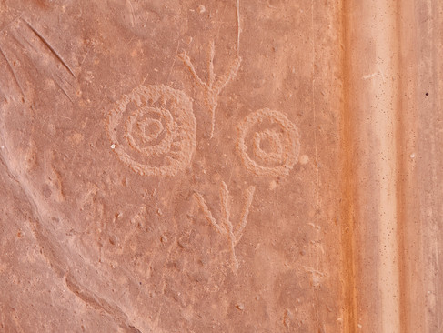
After half an hour of looking around, something unusual catches my eye. At first it looks like a petroglyph, but on closer inspection it isn’t etched at all—it’s raised. Maybe it was once carved and later naturally filled in with minerals, or maybe it’s something else entirely. Either way, it doesn’t appear natural.

I flip through the notebook tucked inside an old ammo box at the alcove’s entrance—pages filled with names of visitors from near and far: Washington, Texas, Louisiana, New York, Nevada, Connecticut, British Columbia, and even as far away as Austria.

Curious about the alcove’s true scale, I launch my drone for a few minutes. From above, the size becomes clearer: at least 60 feet wide and 30 feet deep—vast by any measure.

I hang around for another fifteen minutes, soaking in the view, before retracing my steps back to the trailhead, just in time to pick up my dad for dinner and a sunset visit to the Toadstool Hoodoos. Another gorgeous evening settles over Kanab, and the Mansard Trail hasn't disappointed.


