Hiking to Jeep Arch
- Dan Wagner
- Apr 15, 2025
- 3 min read
Updated: Jun 19, 2025
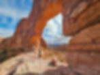
Jeep Arch, located just outside of Moab, Utah, is a striking natural sandstone formation named for its resemblance to the outline of a classic Jeep. Perched high above Culvert Canyon, the arch spans approximately 66 feet and offers sweeping views of the surrounding red rock landscape, including glimpses of Arches National Park, the La Sal Mountains, Amasa Back, and more. The hike to Jeep Arch, also known as Gold Bar Arch, involves a passage through a culvert, a climb over slickrock, and some minor route-finding, but it rewards hikers with solitude, dramatic scenery, and a unique perspective on the high desert terrain.

Trailhead elevation 3,980'
Water none
Don't miss the views of Arches National Park and the La Sals from the backside of Jeep Arch
Hiking to Jeep Arch
I'm back in Moab for the afternoon and decide to finally check out Jeep Arch—one of the few arches outside Arches National Park that I’ve somehow missed over the years. After grabbing a quick bite in town, I head down Potash Road. About half a mile past the Corona and Bowtie Arch Trailhead, I reach the unmarked parking area and pull over to start the hike.
The trail begins by passing through a large culvert cut into a steep hillside.
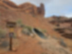
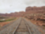
It’s an unusual start, but once I’m through, I climb up the other side and follow the nearby Union Pacific rails along the Kane Creek Branch for a short stretch.
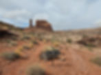
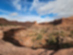
Soon, the route shifts onto a wide slickrock plateau. Green blazes painted onto the slickrock help guide me through Culvert Canyon, where the landscape opens up with towering Navajo Sandstone cliffs and scattered desert plants. The trail is generally easy to follow, though I do check my map a couple of times just to stay on track.
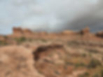


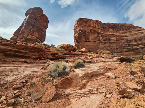
After about a mile, I reach a signed trail junction and take the left fork. A little farther along, I climb a steep slope between a tall spire and a massive sandstone fin.
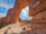
At the top, cairns lead the way across more slickrock. Eventually, Jeep Arch comes into view off to the right—named for its resemblance to the silhouette of a Jeep.


I make my way up a short sandstone ledge and step inside the arch just as the skies are starting to clear. From here, the views are incredible to the south, with wide-open canyon country stretching for miles.

As the skies clear, the sun shows itself, casting its warm light on the east side of the 66-foot-wide arch. I’ve got the place to myself, so I hang out for a while, soaking in the views and the quiet.
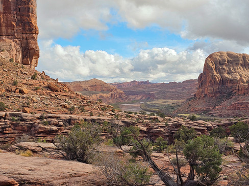
On the way back, I finish the lollipop loop around the backside of the arch, which gives me another perspective of the La Sals and the distant outline of Arches National Park. The return hike south toward the trailhead is just as scenic, with evening light softening the desert around me. Nearing the trailhead, I'm greeted with a beautiful view of the Colorado River and a view that stretches forever.


Back at the trailhead, I hop in the truck and make my way to Kings Bottom Campground, looking forward to the next few days of exploring Bears Ears National Monument. The evening comes to a close reading a few dozen pages of David Day's Canyonlands National Park Favorite Jeep Roads & Hiking Trails, a book that never seems to leave my side.


