South Manitou's Old Growth Cedars Trail: Where Ancient Trees Meet a Sunken Ship
- Dan Wagner

- Sep 2, 2025
- 7 min read
Updated: Sep 3, 2025
Hiking the South Manitou Old Growth Cedars Trail in Sleeping Bear Dunes National Lakeshore is a serene and immersive experience, weaving through a mix of sandy paths, compact dirt, and wooden boardwalks shaded by birch, maple, and yew. Along the way, hikers pass Florence Lake, the island’s only inland lake, and can catch glimpses of historic shipwrecks resting just offshore. The trail leads to a grove of ancient Champion cedars, some over 700 years old, towering above the forest floor and offering a rare glimpse of the island’s pre-logging landscape. Interspersed with remnants of the island’s past—lighthouse views, old farm equipment, and interpretive signs—the hike combines natural beauty, quiet solitude, and a sense of history, all framed by the sparkling waters of Lake Michigan and distant mainland vistas.


Trailhead elevation 587'
Water Filterable from Florence Lake & Lake Michigan
Don't miss the Francisco Morazan shipwreck
Hiking the Old Growth Cedars Trail
After a long day of ups and downs on Pyramid Point and a relaxed evening watching the sunset and a campfire glow on Esch Beach, Heather and I are ready for our next adventure. Today we’re catching the ferry to South Manitou Island to hike the Old Growth Cedars Trail. With Labor Day weekend in full swing, we’re hoping the island gives us a little space to escape the crowds.
A couple of weeks back, I booked tickets on the Mishe-Mokwa, the Manitou Island Transit ferry that runs from the historic harbor town of Leland out to the island. From Empire it’s about a forty-minute drive, and we roll into town with an hour to spare—enough time to check in, grab our NPS pass, stop at Two Fish, and then make our way down to the dock for the 10 AM departure.
By the time we board, the decks are already packed with weekend travelers, so we head for the bow. It turns out to be the perfect spot. The sky is a crisp September blue, the air in the high 60s, and the lake looks about as inviting as it gets. As the ferry pulls away, Whaleback and Pyramid Point fade into the distance, and soon the boat is skimming across the Manitou Passage. The ninety-minute, 18-mile ride goes quickly, and little by little, South Manitou comes into view. First, just a faint shoreline. Then, the lighthouse—a white tower standing tall at the edge of the island. It feels like the moment where the trip really begins.


We land on the island’s crystal-clear shoreline, where a crowd of backpackers and campers waits on the dock for the ferry to carry them back to the mainland. Just beyond, two old U.S. Life-Saving Service boathouses stand near the National Park Service ranger station, while the South Manitou Island Lighthouse rises in the distance to the south.


We quickly depart, then make our way to South Manitou Village where we learn a bit about the island's history. Like so many places on the Great Lakes, South Manitou Island carries a layered history that stretches far beyond its modern role as a hiker’s escape. Long before lighthouses and steamships, the Anishinaabe peoples used the island seasonally for fishing, hunting, and berry gathering, threading it into their travel routes across Lake Michigan.
European explorers passed through the Manitou Passage as early as the 1600s, but the island’s real importance grew in the 1800s when shipping traffic on the Great Lakes exploded. The U.S. government built a lighthouse in 1839 to help guide vessels safely through the busy, storm-prone waters. A later version of that lighthouse, built in 1871, still stands tall today.
For a time, the island supported a small but determined farming community. Settlers raised rye, potatoes, and livestock, and cut timber for passing steamships that stopped to refuel. The island’s ancient white cedar forest became one of its defining features — and even today, a handful of those towering giants still stand, hidden away in a secluded grove near the island’s southwestern shore.
By the mid-1900s, life on the island grew harder. Farming in sandy soil was never easy, and as coal replaced wood for ship fuel, one of South Manitou’s main industries vanished. Families slowly drifted back to the mainland, and by the 1970s, the last permanent residents were gone. That same decade, a new chapter began. In 1970, South Manitou became part of Sleeping Bear Dunes National Lakeshore, preserved not only for its natural beauty but also for its cultural history.
After a quick introduction to the island’s history, we set out along the sandy trail. The path leads us past the park’s visitor center, where rusting century-old farm equipment rests in the grass, but with limited time, we decide to keep moving.


Beyond the visitor center, a wooden boardwalk carries us toward the 104-foot-tall South Manitou Island Lighthouse and keeper's quarters.

We pause here, taking in the sweeping 180-degree views and learning a bit about the families who once called this place home — the Sheridans, the Burdicks, and the Roses — each leaving their own mark on the island’s story.


Early life on the island was harsh, and of the three families, none endured greater heartbreak than the Sheridans. In 1866, Aaron Sheridan, a Civil War veteran, was appointed Keeper of the South Manitou Island Lighthouse. He and his wife, Julia, raised a family here, eventually welcoming six sons. After the new 104-foot tower was completed, Julia herself was named the island’s first Assistant Keeper — the only woman ever to serve in that role. Sadly, tragedy struck in March of 1878 when Aaron, Julia, and their youngest son, Robert, were returning to the island by boat. Their vessel capsized, and all three were lost to the lake. The five surviving Sheridan children went on to live with their grandparents on the mainland. Today, the family’s story is still remembered and told on an informative placard inside the lighthouse. Descendants of Aaron and Julia continue to visit the island, and in 2006, they placed headstones for the three in the cemetery near the island's center.


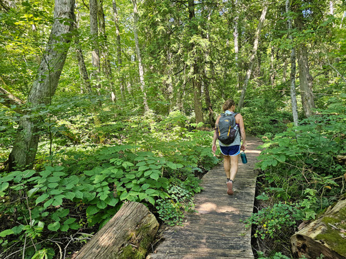
After exploring the lighthouse, we return to the main trail, following the southern, forested edge of the island. The shaded path shifts between wooden boardwalks, compact dirt, and sandy stretches, surrounded by stands of birch, maple, and Canadian yew.

Around 2 miles into our hike, we pass Florence Lake, the island's only inland lake, spanning 78 acres. The mosquitoes here are relentless, so our stop is brief, just long enough to take in the view before pressing on.

Just past Florence Lake, we come to a marked junction leading to the historic farmsteads of early island settlers—Theodore and August Beck, James Sheridan, and George Conrad Huntzler. With little time to spare, we decide to keep going. Not long after, about 2.5 miles into the hike, we reach another well-marked junction, an arrow pointing left toward a “shipwreck.” Surprised to find a wreck along the trail, we happily take the detour. A short third-of-a-mile stroll brings us to the edge of a steep bluff, and through a break in the trees, we spot it: the Francisco Morazan, resting about 300 yards offshore.


On November 28, 1960, the Morazan ran aground after a 38-year career that saw her sail under eight names, six flags, and for eleven different owners. The ship had departed Chicago the day before, carrying more than 1,000 tons of cargo bound for the Netherlands and Germany — everything from canned chicken to shampoo bottles, toys, and more. She was racing against time to reach the Atlantic before the St. Lawrence Seaway closed on December 3.


This voyage was the first command for Captain Eduardo Trivizas. Onboard were twelve crew members and the captain’s pregnant wife, Anastasia. Fog slowed their progress, and a faulty feeder pump forced the ship to drift for eight hours while repairs were made. By 7:15 pm, the Morazan passed Point Betsie in a blinding snowstorm, was pushed off course, and ran aground just 300 yards from the island’s shore.


Three Coast Guard vessels and a civilian tug responded to the mayday, but by December 4, it was clear the ship could not be saved. The crew was safely removed, and while attempts were made to salvage the cargo, they were ultimately abandoned.

After the detour, Heather and I head back to the main trail and make our way toward the old-growth cedar grove. When we arrive, a group of guides from Manitou Island Transit is giving a talk to visitors who were shuttled to this part of the island. We pause for a few minutes, learning that these Champion cedars began growing more than 700 years ago, back when this area was a swamp. Over a century ago, South Manitou Island was home to thousands of towering Champion cedars, but nearly all were cleared for timber long ago. The sight is impressive, but not wanting to linger in the crowd, we decide to continue on our hike, stopping to view more massive cedars along the way.


We make our way toward a nearby stretch of sand dunes, but with time slipping by and a swim calling before the ferry arrives, we turn back toward the lighthouse. By the time we reach the beach near the lighthouse, we have about an hour to spare, just enough time for a quick dip and some fun in the sun. It’s early September, and the water is still a bit chilly, but it’s perfect for rinsing off two days’ worth of hiking funk. From this spot, the view stretches across the horizon, taking in North Manitou Island, Sleeping Bear Point, Pyramid Point, and several other mainland landmarks. I tempt Heather with another skinny dip, but she doesn't take the bait.


With 4:00 fast approaching, we make our way back to the dock, where the Mishe-Mokwa is waiting to carry us back to Leland and burgers at Rick’s Café.

A perfect day on the island comes to a close, but we’ll be back — next time to backpack and explore the parts of the island we didn’t have time to see on this trip. Thanks for the memories, South Manitou! We had a blast.


Hi Dan,
My name is Elizabeth Marino--I work with exhibition development firm The Design Minds, based in Fairfax, VA. We are currently working with National Park Service staff to design new exhibits on North Manitou Island in Sleeping Bear Dunes National Lakeshore. We are hoping to obtain high resolution image files and rights to use two of the images in this blog post in the exhibition. Please reach out to me at elizabeth@thedesignminds.com to arrange it. Happy to answer any questions you may have.
Thanks,
Elizabeth