Hiking the Deer Lick Cave Trail in Brecksville Reservation
- Dan Wagner
- Jun 17, 2025
- 3 min read
Updated: Oct 22, 2025
The roughly 4-mile loop winds through wooded hills, meadows, and shaded ravines, with about 500 feet of elevation gain spread across gentle terrain and a few short, steep climbs. The trail is well-marked and includes several stream crossings over charming wooden footbridges, which add variety and interest to the hike. A key highlight is the namesake Deer Lick Cave—a shallow sandstone overhang that’s especially striking after rainfall when water trickles down the rock face. Though not a true cave, the formation is a local favorite and often accompanied by a seasonal waterfall.

Trailhead elevation 841'
Water filterable throughout
Don't miss stopping to hike the Gorge Trail after
Hiking Deer Lick Cave
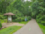
It’s a humid evening in mid-June, and with a few free hours before meeting up with Heather, I make a quick stop at Deer Lick Cave—one of my favorite nearby trails. The trailhead sits just off the parking lot, beginning with a brief paved stretch that passes a large restroom, a learning center, and the Brecksville Reservation Nature Center.


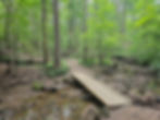
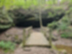
From there, the path drops down a flight of 60 stairs into a shady ravine, where a small wooden footbridge crosses Wallin Creek. On the other side, the trail climbs another 60 steps, rising back out of the ravine.


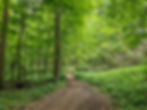
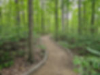
At the top, the red-blazed trail winds through gently rolling forest, offering the occasional glimpse of Wallin Creek far below. A dense canopy of hardwoods keeps the path shaded as it twists and turns beneath the trees.
Around the one-mile mark, I hop across a shallow stream, climb a mild incline, and soon find myself tracing the edge of Chippewa Creek Drive.


I pass the Lower Chippewa Picnic Area—a great alternative starting point if the main lot had been full—before diving back into the woods for a steep-ish, quarter-mile climb.
The trail continues over gentle, rolling terrain before merging with the blue-blazed Buckeye Trail—Ohio’s longest continuous hiking route.

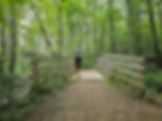
As I move along, the path crosses several wooden footbridges and climbs a series of timber-framed steps, eventually leading to a narrow boardwalk.

Just beyond the boardwalk lies one of the most scenic sections of the loop, where tree-lined borders frame the trail as it meanders deeper into the forest.
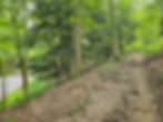
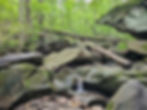
At the 2.4-mile mark, the Deer Lick Cave Trail splits from the Buckeye Trail and begins a rocky descent down rough-cut stone steps. The path soon levels out and arrives at the trail’s namesake feature: Deer Lick Cave. Despite the name, it’s not a true cave but rather a shallow sandstone overhang, framed by massive boulders and a slow-moving stream. The ledge is partially flooded today, so after a quick glance, I continue on.


Just beyond, another smaller overhang appears, this one accompanied by a series of delicate cascades fed by recent rain.


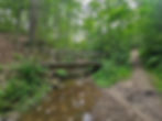
Around mile 2.7, I stop at yet another wooden footbridge—maybe the tenth or twelfth so far—and take a moment to catch my breath.


Refreshed, I push ahead as the trail rises and dips through the forest, crossing a few final streams and another boardwalk area before descending the staircase above Wallin Creek and emerging near the Nature Center.


With a little daylight still to spare before meeting up with Heather, I reach the trailhead in good time, ready to squeeze in one more trail—this time to Deep Lock Quarry, one of the last local trails still on my list. My hike on the Deer Lick Cave Loop comes to an end—for now. Like countless times before, I know I’ll find my way back. It's far too beautiful not to return.


