Hiking to the N28901 Plane Crash Site in Cranberry Wilderness
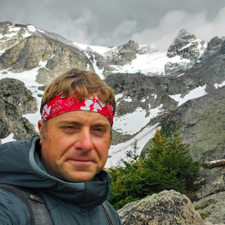
- Dan Wagner
- Oct 1, 2023
- 4 min read
Updated: Jun 9, 2024
On the morning of November 28, 1995, Colin Campbell, a 31-year-old pilot employed by Casey Industries, embarked on a flight from Braxton County Airport in West Virginia to his home in Lynchburg, Virginia, piloting a twin-engine Cessna 414. The flight departed at 9:30 AM and there was initial radio communication between Campbell and air traffic control. However, just eleven minutes into the flight, at 9:41 AM, the aircraft vanished from radar. In the days that ensued, exhaustive search efforts were launched in an attempt to locate Campbell and his Cessna, but they could not be found.
It wasn't until November 14, 2001, six years after the fateful disappearance, that a local paragliding instructor stumbled upon the wreckage of the aircraft. Sadly, Campbell's body was never recovered and is thought to have been taken by wildlife.


Today, accessing the crash site has become relatively straightforward if you know where to go. The hike to the site involves the utilization of three trails: the North Fork, Big Beechy, and District Line Trails, as well a bit of off trail navigation through dense forest.


Trailhead elevation 4,232'
Water none
Don't miss backcountry campsites along Big Beechy
Hiking to the Cranberry Wilderness N28901 Plane Crash Site
The hike begins from a large unsigned gravel parking area off of Highland Scenic Highway at coordinates 38.2956076, -80.2486870. This parking area is also the starting point for the Big Beech/Middle Fork Loop, and is located just 5 minutes from the trailhead for the North-South Loop, both of which are excellent backpacking loops in Cranberry Wilderness.

The initial quarter mile follows the North Fork Trail, passing a trail kiosk before reaching a signed intersection with the Big Beechy Trail.

After making a right turn onto the Big Beechy Trail, the path gradually ascends, eventually plateauing within a dense pine and spruce forest and forest floor blanketed in moss in all directions. The scenery is remarkable and strikingly similar to that of the North-South Loop, which is located a short distance to the south in Cranberry Wilderness.

The video below highlights the splendor of the Big Beechy Trail and offers a glimpse of what awaits during the warmer seasons of the year. More than half of the path leading to the crash site shares a similar scenic appeal.
At 2.5 miles in, the Big Beechy Trail intersects with the District Line Trail.

Here, hikers should veer right and follow the District Line Trail for 1.5 miles. While the District Line Trail may not offer the same level of scenic beauty as Big Beechy, it does have a few remarkably beautiful stretches of moss-covered terrain. Upon reaching the 3.95 mile-mark, which corresponds to coordinates 38.3330028, -80.2758393, hikers should leave the trail and take a left into the woods. As you descend the gentle slope of the mountain, hikers will encounter the aircraft's cabin roughly one-third of a mile downhill at coordinates 38.3338943, -80.2798418.

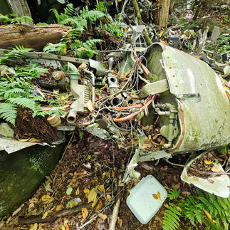
Sitting atop a large sandstone slab, the cabin, severed in half, serves as the end of the debris path. Looking through the rear of the rear, you can see the interior of the cabin, where two seats remain well-intact, including the pilot's seat.

As hikers move towards the cabin's front, they can crouch down to get a much better vantage point inside. While forest creatures have been chewing away at one of the chairs, the second chair has held up remarkably well, considering its age.

Just below the sandstone slab lies one of the propellers.

Directly below the cabin lies one very large section of landing gear, part of a wing, a fuel bladder, and more.

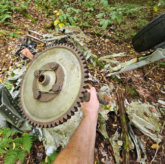
Surrounding the cabin are various fragments including the aircraft's maintenance and recordkeeping system manual, an instrumentation panel, engine parts, gears, flight controls, and much more. This site contains much more identifiable wreckage than the Spruce Knob Piper PA-23 site, located 2 hours north of Cranberry Wilderness, and sees significantly less foot traffic.


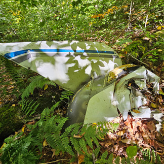
As hikers descend further downhill, they will be heading towards the point where the aircraft first struck the treetops and the start of the debris field. Approximately 100 feet from the cabin, the remainder of the fuselage and one of the plane's wings can be found. A prominent indication of the wing's impact with a tree is the noticeable and sizable gash it bears.

Just behind this section of the fuselage, one of the aircraft's two propellers lies partly buried in the ground.

100 feet further downhill, at coordinates 38.3344677, -80.2804038, there are numerous fragments of the plane, including various fuselage and wing segments, a second wheel, landing gear, and more.


After exploring the site, hikers simply retrace their steps back to the trailhead.
Cranberry Wilderness is a very remote region and offers little to no cell phone coverage. Prior to venturing off trail, hikers should have above average navigation skills and proper animal safety equipment. It's also advisable to download the area on offline Google Maps to input the wreckage coordinates or use AllTrails to track the off trail portion of the hike so you know how to get back to the District Line Trail. Case in point: In June 2011, Michael Camellitii, a former Army Special Forces Colonel, ventured into Cranberry Wilderness and disappeared without a trace. Despite extensive search efforts, his whereabouts remain unknown to this day.

To explore more hikes related to plane crashes, check out Plane Crash Hikes.
Campsites
For those considering backpacking the trail, there are three established campsites equipped with stone fire pits available. Backpackers will also encounter an open space where two or three tents can be put down just after you venture off trail from the District Line Trail. The mileage references provided below are distances from the parking area. While the USFS does not mandate bear canisters, they are strongly encouraged due to the presence of a small black bear population in the vicinity. There are no fees or permits required for camping at any of the sites listed below.
#1 0.60 miles, room for 2 tents, two small stone benches.

#2 1.85 miles, room for 3 tents.

#3 2.5 miles, room for 3 tents.

#4 4.05 miles, room for 2 tents, very rooty, no fire ring, located 30 feet off of the District Line Trail.


Hello I was wondering if you would happen to know Colin Campbell's birth date? He was in the plane crash on Cranberry Mountain in W.Va in 1995.