Backpack the Big Beechy/Middle Fork Loop in Cranberry Wilderness
- Dan Wagner
- Mar 30, 2024
- 4 min read
Updated: Jun 9, 2024
A good beginner backpacking loop in the heart of West Virginia's Cranberry Wilderness, one of the largest designated wilderness areas east of the Mississippi. The loop offers an incredible amount of solitude, landscapes similar to the Pacific Northwest, numerous waterfalls, and exceptional backcountry camping. Due to a few areas where the trail is challenging to locate, a downloaded trail map is recommended. In the spring, water shoes and hiking poles can prove useful when fording both Beechy Run and the Middle Fork Williams River. While encountering blacks bears is uncommon, proper food storage is highly recommended.

Trailhead elevation 4,259'
Water Beechy Run and throughout the Middle Fork Trail
Don't miss the waterfall campsite along Big Beechy Run
Backpack the Big Beechy/Middle Fork Loop
The loop starts at the North Fork Trailhead, located off the Highland Scenic Highway at coordinates 38.297485, -80.250516. From the trailhead, the route leads northward for 0.2 miles until it intersects with the clearly marked Big Beechy Trail. The recommended direction to hike the loop is counterclockwise, starting by ascending the Big Beechy Trail. This choice serves two purposes: it postpones encountering mud and water crossings on the Middle Fork Trail until the second day, and it allows for a more gradual ascent out of the valley along the Middle Fork Trail.

From the junction, hikers ascend the southern slope of Sugar Creek Mountain along the Big Beechy Trail. Approximately a half mile in, the scenery transforms from a mix of hardwoods to mostly second-generation pine forest, with a forest floor blanketed in moss in all directions.

Continuing along the trail, hikers will eventually reach the summit of Sugar Creek Mountain at approximately the one-mile mark. Although there are no scenic views atop the mountain, the trail compensates with lush forest scenery reminiscent of the Pacific Northwest.

At the 2.5-mile mark, the trail intersects with the District Line Trail. For those interested in a 5.6-mile (roundtrip) detour, following the District Line Trail will lead to the site of the Cessna N28901 plane crash. However, hikers solely focused on completing the Big Beechy/Middle Fork Loop should proceed leftward along the Big Beechy Trail.

Around the 5.7-mile mark, the trail becomes significantly more difficult to navigate due to an abundance of blowdowns, deadfall, and rocky terrain. Hikers should expect a considerable slowdown in their pace from this point until they reach the Middle Fork Trail.

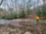
At 7.3 miles, the Big Beechy Trail intersects with the Middle Fork Trail and the confluence of Beechy Run and the Middle Fork Williams River, the first reliable water source along the loop.
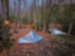
On the far bank of the Beechy Run, hikers will find several established campsites equipped with stone fire pits, including one that overlooks a six-foot-tall waterfall. Typically, crossing Beechy Run is no more than ankle-deep, but during periods of heavy rainfall, the water level may rise to mid-calf or higher. A full list of established campsites along the loop can be found at the bottom of this page.
From this point, the loop continues along the Middle Fork Trail, which runs alongside the Middle Fork Williams River.

The ensuing miles are notorious for their year-round muddiness and abundant blowdowns, much like several stretches along the neighboring North South Loop.
At the 8.8-mile mark, the Middle Fork Trail intersects with the Laurelly Branch Trail. A short walk down to the river along the Laurelly Branch Trail leads to a single tent site on the near bank and a large group site on the far bank. Both are great campsites and each offers easy access to the river to filter water. Those considering camping on the far side of the river, can expect the water level to be as high as mid-thigh during the spring and mid-calf during the summer months.

Continuing along the trail, at the 9.2-mile mark, hikers will encounter two more excellent campsites offering views of two ten-foot waterfalls across the river. On the near side of the river is a three-tent site, while on the far bank lies a large group site.

Beyond this point, hikers will encounter an abundance of small cascades along the river, as well as a number descending from each side of the valley. A notable cascade can be found at the 10.2-mile mark, where the trail skirts beside a large rock slab with cascades descending from either end.

Around 10.7 miles and 11.5 miles, hikers will encounter two river crossings. In springtime and after prolonged rainfall, these crossings can range from ankle to mid-thigh deep. During the summer months, they typically require nothing more than rock hopping. At the 11.1-mile mark, the trail passes beside a large swimming hole fed by a series of small cascades.

At the 13.1-mile mark, the trail crosses the river one last time, requiring only rock hopping, before the start of a gradual ascent out of the valley. At 15.5 miles, the trail intersects with the North Fork Trail, where hikers should veer left and follow the Middle Fork Trail another 1.2 miles to the trailhead.
Campsites
The campsites below all come equipped with a stone fire pit. Mileage is listed from the trailhead, hiking counterclockwise. There are likely others along the loop, but these are the ones that I noticed.
0.5 miles on the left (2 tents)
1.9 miles on the right (3 tents)
2.5 miles on the right (2 tents)
4.9 miles on the right (3 tents)
7.3 miles (3 tents, far side of Big Beechy Run, waterfall site)
7.3 miles (4 tents, far side of Big Beechy Run, adjacent to the site above)
7.5 miles on the right (2 tents, first site along Middle Fork Trail)
8.8 miles on the right (1 tent on the near bank, 4 tents on the far bank)
9.2 miles on the right (3 tents on the near bank, 4+ tents on the far bank, waterfall site)
10.3 miles on the opposite side of the river (4 tents)
11.7 miles on the right (3 tents)
11.8 miles on the right (3 tents)
13.3 miles on the right (3 tents)


