
262 Steps Into Hell: Hiking Hell Hollow Wilderness Area

Located in Leroy Township, Ohio, Hell Hollow Wilderness Area is home to one of Lake County's most fascinating hiking destinations, where ancient shale cliffs, a rugged gorge, and a hidden waterfall create a surprisingly dramatic landscape. Managed by Lake Metroparks, the 1000-acre nature preserve features the Beech Ridge Trail, a short woodland trail that leads to an overlook high above Paine Creek. Along the way, hikers can discover the area's unusual name, its forgotten industrial history, and geological formations dating back more than 300 million years. For those willing to tackle the steep descent into the gorge, the adjoining Wildcat Trail provides access to a secluded creek valley and its picturesque cascades.

Trail Info
Length 2 miles
Elevation gain 225 feet
Route Out & back
Permit required No
Dogs allowed On leash
Trailhead elevation 1,015'
Water none
Hiking Hell Hollow Wilderness
The hike begins at the main parking area along Leroy Center Road, where visitors will find a picnic shelter, restrooms, and a trail info kiosk.

From the parking lot, the trail enters a mature hardwood forest, following a relatively wide, well-maintained path beneath a canopy of beech, maple, and other deciduous trees.

As the trail winds through the forest, it's difficult to imagine that this peaceful landscape was once a bustling center of industrial activity. During the mid-1800s, Leroy Township supported a thriving lumber industry, with the 1850 manufacturing census recording 11 sawmills throughout the township. The largest reportedly processed approximately 400,000 feet of lumber that year, an impressive figure for a rural community in northeastern Ohio.

Several of these mills operated in or near what is now Hell Hollow Wilderness Area. Two stood within the boundaries of the present-day preserve, while another was located farther south near what is now Camp Lejnar. One of the mills even maintained a dam and millpond along Paine Creek, harnessing the stream's flowing water to power its machinery. Additional sawmills and gristmills operated along nearby Bates Creek, another important waterway in the area's early industrial development.

The mills weren't the only signs of civilization in Hell Hollow. During the 19th century, farms, homes, and small rural schools occupied portions of the surrounding landscape. Historical records identify two schools in the vicinity, including one on land that eventually became part of the preserve. As the lumber industry declined and local land use changed, many of these buildings disappeared, allowing the surrounding forest to gradually reclaim the landscape. Today, remnants of old foundations and other structures reportedly survive in parts of the wilderness area, offering subtle reminders of the community that once existed here.
Continuing along the trail, the forest parallels the edge of the Paine Creek gorge. A fenced overlook provides an impressive view into the valley below, where the creek winds between steep, forested hillsides. The scenery is particularly beautiful during autumn, when the surrounding hardwoods turn brilliant shades of yellow, orange, and red.
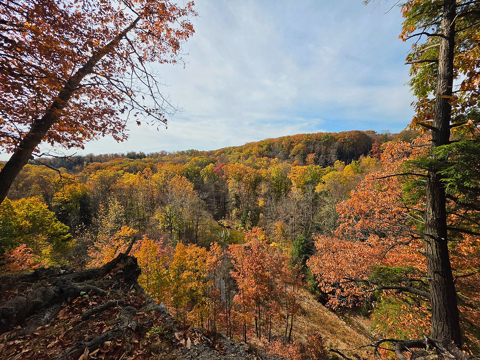
The gorge itself is one of Hell Hollow's most remarkable natural features. Rising more than 100 feet above the creek in places, its exposed walls reveal layers of Chagrin Shale deposited approximately 360 million years ago. At that time, much of northeastern Ohio lay beneath an ancient sea, where fine sediments accumulated on the seafloor and gradually hardened into the rock visible today.

Millions of years later, the advance and retreat of continental glaciers dramatically altered the surrounding landscape. As the last glaciers melted, flowing water helped establish the drainage systems that eventually carved deep valleys through the region's underlying bedrock. Over time, Paine Creek eroded the relatively soft shale, creating the steep-sided gorge that makes Hell Hollow such an unusual hiking destination.
The rugged terrain also helps explain the preserve's rather ominous name. According to local historical accounts, Hell Hollow earned its name because of the extraordinary difficulty early settlers encountered while traveling into and out of the ravine. Before wooden staircases and maintained hiking trails existed, navigating the steep, slippery slopes was an exhausting undertaking, particularly for those hauling timber or equipment. The experience was apparently unpleasant enough that the name Hell Hollow eventually stuck.

Interestingly, Hell Hollow isn't the only Lake County preserve with a name inspired by its difficult terrain. Penitentiary Glen Reservation in nearby Kirtland received its similarly intimidating name because of the steep ravine walls that made escaping the valley exceptionally challenging.
For hikers interested in exploring beyond the overlook, the trail descends into the heart of Paine Creek Gorge. The descent begins with a long wooden staircase consisting of 262 steps that winds down the steep hillside toward the valley floor.

As the staircase drops below the surrounding treetops, the character of the forest begins to change. The relatively open hardwood forest along the ridge gives way to a cooler, more sheltered environment, where eastern hemlocks and moisture-loving plants thrive along the steep slopes.

Eventually, the staircase reaches the bottom of the gorge, where hikers can continue along the Wildcat Trail and Paine Creek. However, the trail is notoriously difficult to follow due to its incredibly poor markings, making it highly recommended that hikers download a trail map before setting out. Even with a map, route finding is often required, especially in fall when leaves blanket the forest floor.

After a bit of careful navigation, the trail eventually leads hikers to the highlight of the hike: Angel Falls. The secluded, roughly 10-foot waterfall cascades over a broad ledge of ancient Chagrin Shale before spilling into a pool below. Surrounded by gorge walls, moss-covered rocks, and dense forest, Angel Falls feels remarkably isolated from the outside world. Its remote location and rugged surroundings make it one of Lake County's more intriguing hidden waterfalls.
After enjoying the waterfalls and the scenery of Paine Creek, hikers can either venture off trail downstream and through the creek to two less-known waterfalls or retrace their steps to the wooden staircase. The return climb is easily the most strenuous part of the outing, with all 262 steps standing between the creek and the forested ridge above. It's also a fitting reminder of why early settlers gave the hollow its unusual name.

For those interested in exploring more of Lake County's geological and industrial history, nearby Paine Falls Park offers another opportunity to experience the scenic beauty of Paine Creek. Both parks share connections to the region's early water-powered industries and the ancient rock formations that helped shape northeastern Ohio's landscape.
Although Hell Hollow Wilderness Area is often overshadowed by Lake County's larger and more popular parks, its combination of unusual history, ancient geology, and rugged natural beauty makes the Beech Ridge and Wildcat trails a rewarding outing. What begins as a peaceful walk through the woods ultimately leads into a dramatic shale gorge, where the sound of flowing water and the remains of a long-forgotten industrial landscape tell the story of one of northeastern Ohio's more intriguing wilderness areas.


Comments