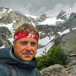
Hiking to Sharp Top Mountain's B-25 Bomber Crash Site
- Dan Wagner
- Jun 19, 2023
- 4 min read
Updated: Jun 9, 2024
Enjoy a sensational sunrise, discover the remains of a 1943 B-25 bomber, and get in some light scrambling on a moderately strenuous day hike in Virginia's storied Peaks of Otter.


Trailhead elevation 2,556'
Water None
Don't miss Sunrise from Sharp Top's summit and scrambling at Buzzard's Roost
Hiking Sharp Top Mountain & B-25 Bomber Crash Site
Situated within Jefferson National Forest, the trailhead for Sharp Top is located along a beautiful stretch of the Blue Ridge Parkway. It's important to note that both the sizable parking lot at the trailhead and the overflow lot at the nearby Peaks of Otter Visitor Center tend to reach capacity quickly, particularly on weekends. To the right of the trailhead you'll find the Sharp Top Store, a convenient stop to grab food and drinks for the hike.

Starting from the trailhead, the moderate climb up Sharp Top Mountain begins almost immediately. The easy to follow trail ascends the western slope of the mountain, gaining more than 800' in elevation within the initial mile. The trail comprises various terrain, ranging from dirt path and scattered stones to rock slabs, stone staircases, and more. At 1.2 miles a clearly marked junction appears, presenting a spur trail leading to Buzzard's Roost. Choosing the main path to the left and continuing for another quarter mile entails an additional elevation gain of 400', ultimately leading to the summit. If you manage to reach the summit by sunrise, you'll be rewarded with arguably one of the best sunrise views in the state.

Once at the summit, Flat Top Mountain (3,973') lies to the northeast and rising above Abbott Lake to the north is Harkening Hill (3,353'), which along with Sharp Top (3,875') make up the Peaks of Otter. It's noteworthy to mention that archaeological evidence uncovered during the construction of Abbott Lake in 1964 indicates that Native Americans had been present in the area as early as 8,000 years ago.
During America's infancy, Sharp Top held a prominent position in the nation's perception, with Thomas Jefferson among those who believed it to be the tallest mountain the country, if not the entirety of North America. Its grandeur was held in such high regard that stones from its peak were sent to Washington, D.C. to be used in the construction of the iconic Washington Monument.

Near the summit, visitors will encounter stone stairs, walkways, and a stone shelter that dates back to the 1930s. Multiple vantage points along the summit offer plenty of opportunities to appreciate the breathtaking views. However, solitude is scarce at the summit, as it ranks among the most popular hikes in Virginia.
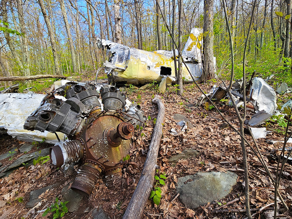
In order to reach the bomber crash site, return along the same path until reaching the junction with Buzzard's Roost. From there, a narrow yet clearly defined trail veers to the left. This unmarked spur trail descends the southern slope of the mountain, gradually becoming steeper as you progress. After a quarter mile and 450' in elevation loss you'll arrive at the crash site, which is located near coordinates 37.42778, -79.60664. As you descend the path, the first wreckage that you'll come across is the plane's engine, situated right beside the trail.

Immediately after the engine, you'll find two segments of the plane partially buried in the slope of the mountain. The Army Air Force North American B-25 Mitchell, carrying five US Army Air Force servicemen, was en route to Lynchburg, Virginia from Columbia Army Air Base in South Carolina performing a low-level nighttime navigational training mission on February 2, 1943, when it crashed into the mountain around 3,100'. All five men aboard were killed, including 2nd Lieutenants Paul Pitts, William McClure, George Beninga, and Hilary Blackwell, as well as Corporal Peter Biscan.

Continuing a brief distance from there, you will come across a section of the plane's fuselage, accompanied by one of its wings that remains connected. This marks a rare occurrence of a plane crash site east of the Mississippi where the wing of the aircraft remains attached. In comparison, the Cranberry Wilderness N28901 site, located 3 hours away in West Virginia, and the Spruce Knob Piper PA-23 site, also in West Virginia, feature wings, but they are either detached or completely destroyed.

As you walk beneath the fuselage, you'll have the opportunity to view the wing along a steep slope.

Numerous fragments of smaller debris are strewn in various directions, though identifying what exactly they are can prove challenging. A significant landmark to note is a memorial plaque on a large boulder. The plaque was installed on the crash's 58th anniversary and can be found near coordinates 37.4277606, -79.6065765.

The forest is slowly reclaiming the crash wreckage, but for now there is plenty to explore. Please keep in mind that it is illegal to remove debris from the site. Take only photos, leave only footprints, and allow others to visit the site as long as nature permits.
To reach Buzzard's Roost, simply retrace your steps and connect with the signed 0.1-mile-long Buzzard's Roost spur trail. While the view from the west-facing overlook may not match the grandeur of Sharp Top's panoramic summit, it does offer fun scrambling opportunities. Those without a fear of heights shouldn't pass up Buzzard's Roost.
After Buzzard's Roost, head back down the mountain to the trailhead. If you're traveling north along the Blue Ridge Parkway after your hike, consider stopping at either Upper Goose Creek Valley Overlook or Porter Mountain View Overlook. Both are only a handful of miles from the Sharp Top trailhead and have excellent views.
For additional plane crash sites, consider reading Plane Crash Hikes, which details numerous sites in nearby states.


This crash occured on the same day my dad was born, so I've been to the site maybe 5 times. Trail is not marked (for obvious reasons) and extremely steep coming back up. It's a sobering feeling being there. If a person wants to find it, when you get to the marker that says Buzzards Roost And Sharp Top, turn to go towards Buzzards Roost. Maybe ten yards, there will be a faint trail to the left. Follow this as it goes down, and wraps around the mountain clockwise. I'd go after the leaves fall, as you can see more, and won't have to worry about Rattlers. Even though I've never seen one on Sharp Top. And as mentioned bel…
Please tread softly on this aerial grave out of respect for the dead and those that still mourn them.