Hike to Grandfather Mountain's Cessna 182Q Skylane N735MB Crash Site
- Dan Wagner
- Mar 4, 2024
- 5 min read
Updated: Jun 9, 2024
Experience stunning ridgeline views, picturesque forest scenery, and uncover the remnants of a tragic 1970s plane crash as you hike towards the summit of Calloway Peak, the tallest peak in North Carolina's Grandfather Mountain State Park. This route incorporates segments of the Nuwati and Tanawha Trails, and the entirety of both the Daniel Boone Scout Trail and Cragway Trails, offering the most direct way to access both the crash site and Calloway Peak.


Trailhead elevation 3,904'
Water Boone Fork Creek
Don't miss the view of Calloway Peak along the Cragway Trail
Hike to Grandfather Mountain's Cessna 182Q Skylane N735MB Crash Site
Starting at the Boone Fork parking area along the Blue Ridge Parkway, the path begins by following the Tanawha Trail. After just 0.15 miles, it crosses a 100-foot long footbridge over Boone Fork Creek, offering hikers glimpses of several small cascades along the way.

Upon reaching the 0.4-mile mark, the Tanawha Trail intersects with the Nuwati Trail. Hikers have the option to proceed straight ahead on the Tanawha Trail or turn right to follow the blue-blazed Nuwati Trail. While both trails lead to the same destination, taking the Nuwati Trail is recommended. This is because the Nuwati Trail presents considerably more rugged terrain, making the ascent easier while legs are fresh, rather than facing it during the descent later on.

If hikers opt to turn right and proceed along the Nuwati Trail, after slightly more than 1 mile, they will encounter a junction with the orange-blazed Cragway Trail, where they should turn left. At this point, the trail begins to noticeably steepen, occasionally revealing glimpses of Calloway Peak from two separate rock outcroppings, with the second one providing the greater view. In the photo below, Calloway Peak can be seen peeking above the ridgeline to the left.

Throughout much of the climb up the Cragway Trail, hikers can enjoy the sound of Boone Fork Creek rushing in the distance, but from the second rock cropping onward, there are only forested views until the summit. At approximately 2.1 miles into the hike, the Cragway Trail intersects with both the white-blazed Daniel Boone Scout Trail and the Tanawha Trail. At this point, hikers should continue along the Daniel Boone Scout Trail, which eventually leads to Calloway Peak.

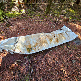
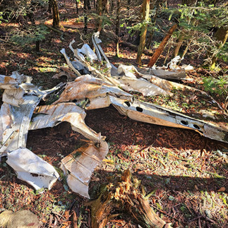
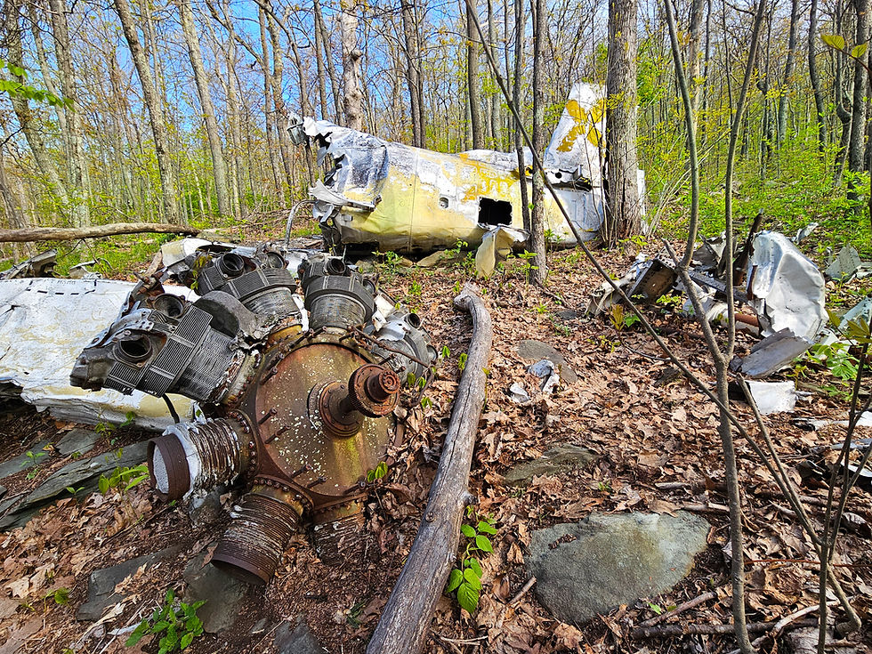
Over the following 1.7 miles, the trail continues to ascend the mountain before reaching the marked Raven's Roost tent platform, positioned along the left side of the trail. On the opposite side of the trail from the platform, hikers should notice an unmarked spur trail extending 50 feet into the forest, ultimately leading to the wreckage of a tragic plane crash.

On the morning of Friday, May 12, 1978, Phillip Kress Dupre, a 47-year-old Pennsylvania native and Korean War veteran, took off from Seven Springs, Pennsylvania, heading to Panama City, Florida in his single engine Cessna 182Q Skylane.

At around 1:00 PM, Dupre contacted Raleigh County Memorial Airport in Beckley, West Virginia, seeking a weather update for Asheville, where he intended to refuel. Sadly, that radio communication was the last time his voice was heard by another person.

Flying at cruising speed amid rain, fog, and low visibility, Dupre crashed into the northern slope of Calloway Peak, the highest point on Grandfather Mountain. When the aircraft failed to appear for its scheduled refuelling stop in Asheville, and Dupre could not be reached via radio, Civil Air Patrol search crews were dispatched across West Virginia, Virginia, Tennessee, and North Carolina.

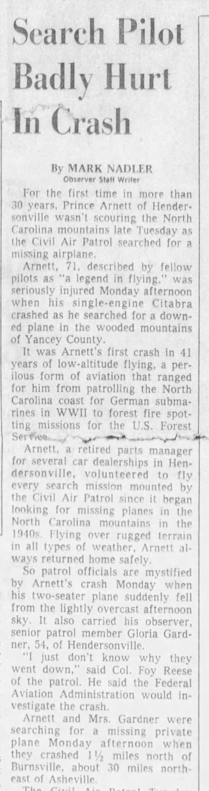
In the pursuit of locating Dupre's Cessna, a two person Civil Air Patrol unit, piloted by 71-year-old Milton Prince Arnett of Henderson, North Carolina, crashed while conducting the search. The incident marked Arnett's first crash in 41 years of low-altitude flying, a career that ranged from patrolling the North Carolina coast for German submarines during WWII to forest fire spotting missions for the US Forest Service. Arnett, hailed as "a legend in flying," and another CAP member, Gloria Gardner, sustained injuries but managed to survive the ordeal.


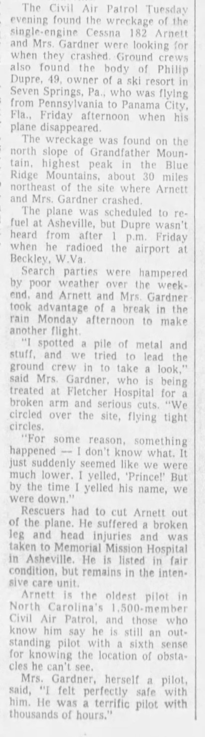
Following Arnett's crash, the search for Dupre's Cessna was halted for two days due to adverse weather conditions. After a two-day pause, search efforts resumed. It wasn't until Tuesday at approximately 1:30 PM that Dupre's aircraft was finally sighted by Winston-Salem based Civil Air Patrol pilot Bob Peters.


Upon discovering the crash site, Peters promptly headed to the Beech Mountain Airport seeking ground assistance. He observed that the debris spanned a path of 200 to 300 yards, likening its scattered arrangement to a bed sheet caught in a tree.

Around 4 PM that same afternoon, a ground crew comprising two CAP cadets, among them Peters' son Brian, were sent out to find Dupre's plane. The young men trudged through dense undergrowth for three miles uphill, while Peters circled overhead, providing directions to one of the cadets' walkie-talkies. Reflecting on the endeavor later, Bob Peters remarked, "It was a very difficult place to get to. The underbrush was so thick that they couldn't see it (the wreck) when they were 30 feet away."

Upon reaching the crash site, the cadets verified Dupre's death, expressing, "We hoped we'd find someone alive, but there was no chance with this one. The plane demolished itself on impact. It disintegrated into the trees in thousands of pieces." Two hours after discovering the crash, a formal rescue team arrived minutes before sunset and established a camp for the night.

Around 4 AM the next morning, Dupre's remains were taken down the mountain and later transported to Caldwell Memorial Hospital in Lenoir.

Dupre, a co-owner of Seven Springs Mountain Resort in Somerset County, Pennsylvania, left behind a wife and four daughters.

After viewing the debris and returning to the Daniel Boone Scout Trail, hikers can walk another 100 feet or so and encounter more debris off the right side of the trail.


A short distance later, the Daniel Boone Scout Trail steepens considerably, ascending towards Calloway Peak through a series of three ladders.

Following the third ladder, the trail ascends even more steeply until reaching Calloway Peak shortly after. Despite its modest size, Calloway Peak's summit offers stunning views of MacRae Peak to the southwest.

After taking in the panoramic views from the summit, hikers can retrace their steps towards the junction of the Daniel Boone Scout Trail, Cragway Trail, and Tanawha Trail. Opting to descend via the Tanawha Trail is recommended, as previously mentioned. Upon returning to the bridge spanning Boone Fork Creek just before the trailhead, a great way for hikers to reward tired feet is by soaking them into the cold water of the creek. The easiest way to reach the creek is to the right immediately after the footbridge.
Those interested in hikes to plane crash sites might also consider visiting the Cessna 182H Skylane N2350X site along the Deep Gap/Black Mountain Crest Trail in Mount Mitchell State Park. For a list of every plane crash hike that I've been on, check out Plane Crash Hikes.


Comments