5 Days Backpacking the Roan Highlands' Iconic Grassy Balds
- Dan Wagner
- Apr 18
- 11 min read
Updated: Apr 26
The 50-mile Roan Highlands section of the Appalachian Trail is widely considered one of the most scenic backpacking routes in the Southeast. Named for the Roan Mountain massif, the stretch is famous for its rolling grassy balds— the longest continuous series in the Appalachian Mountains—offering panoramic views that rival some of the best hikes on the East Coast. Straddling the Tennessee–North Carolina border, the trail climbs across open ridgelines, winds through lush mountain valleys, and delivers endless photo-worthy vistas. For backpackers seeking a challenging multi-day hike with prime backcountry camping, the Roan Highlands provide an unforgettable Appalachian Trail experience.


Trailhead elevation 1,683'
Water throughout, though many sources dry up in summer
Don't miss camping at Beauty Spot, near Grassy Ridge Bald, and/or the Overmountain Camping Area
My buddy Dave and I decide to spend a few days backpacking the Appalachian Trail through the Roan Highlands, hiking from the Chestoa Trailhead in Erwin, Tennessee to the 19E Trailhead in Roan Mountain. It's about 50 miles in all and we plan to spend five days tackling it. We leave my vehicle at Mountain Harbour Bed & Breakfast—a third of a mile from where the AT crosses 19E—for a small fee, then make the drive to Erwin to start our hike.
The day is dominated by a steady climb beneath a canopy of mixed hardwoods, with the trail winding through dense stands of Catawba rhododendron, magnolia, and mountain laurel. We pass water sources along Jones Branch near the 1.5- and 3.5-mile marks, eventually refilling at Shinbone Creek at Indian Grave Gap. From this point on, we encounter no more water sources. After gaining about 3,300 feet of elevation over 11 or so miles, we reach Beauty Spot—a dry camp with sweeping, panoramic views. To the south, a vast sea of peaks unfolds. In the distance, we make out Mount Mitchell—North Carolina’s towering summit and the highest point east of the Mississippi—rising above the rest, with forested ridges and lush valleys stretching out in every direction.

We shed our packs, plop down on a log beside a stone fire ring, and soak in the view for what feels like forever. Eventually, we cook dinner, talk over the miles still ahead, and hang our bear bags in a stand of birch trees a safe distance from camp. About an hour later, we catch a gorgeous sunset from camp, and watch as the sun sinks below the horizon over the Sampson Mountain Wilderness.


The day, which had brought Dave and I few views until camp, ends with crickets and the sound of a gentle breeze against our tents. The next morning, we wake to a fogged-in camp, the sweeping panorama of peaks from the night before now completely hidden. With a long day ahead, Dave quickly makes breakfast, we pack up camp, and set off along the grassy trail as warm morning light begins to break through.


A stretch of gentle climbs and easy descents carries us through open meadows and dense forest before we begin a steep, switchbacking ascent of Unaka Mountain. Sunlight filters through the trees as we inch closer to the summit.

As we climb, the landscape gradually transforms—from groves of sugar maple, white oak, and hemlock to a summit cloaked entirely in a towering stand of red spruce. We pass several dry backcountry sites during the ascent, each around 14 miles in, as well as several on Unaka's summit. Dave's chest infection has gotten worse, so we take a long break at the summit before continuing on. The rest of the day offers no scenic views—just mile after mile of hiking through dense, shadowy forest.


We pass several more backcountry sites around miles 14.9, 16.8, 20.4, 22.5, 23.4, and 23.5. Water is scarce along this stretch, so we top off at a piped spring down a 200-foot spur trail behind the Cherry Gap Shelter, and again from another pipe at Apple Orchard 4.5 miles later. This section also takes us over four tree-covered, viewless summits: Big Ball, Piney Ball, Little Bald Knob, and Piney Bald. We're desperate for any kind of view, but the trail refuses to deliver.
Finally, a little more than 25 miles in, we reach Greasy Creek Gap—a dry site with two large backcountry sites tucked beneath a canopy of trees—and decide to call it a day. Dave is completely wiped out, and pushing on to the Clyde Smith Shelter a few miles away just isn’t in the cards.

The next morning, we start early and tackle Iron Mountain and Little Rock Knob before a long gradual descent to Hughes Gap. During the descent, feeling worse than the previous two days, Dave decides to call a shuttle service to come pick him up at Hughes Gap. He tells me to keep going and finish, but I don't want to leave a sick buddy behind so we end the trip a few days early. Other than Beauty Spot, the first three days are nothing but forested terrain and very little in terms of views. It was a nice workout, but nothing spectacular.
Nearly two years later—about seven months after Hurricane Helene tore through the region—I return to finish the final stretch of the Highlands, hiking the AT from Hughes Gap to 19E. This time, I've booked a shuttle with Mountain Harbour. I arrive there around noon and find that they're building a new hostel. Apparently, the previous one, a 1904 barn-turned-home for the night, was destroyed by the hurricane last year. I pay for the shuttle that I had reserved online a few months back, as well as overnight parking ($50 total), then Gigi, one of Mountain Harbour's owners, drives me about 30 minutes to Hughes Gap, wishes me luck, and sends me on my way.


The hike begins with a steady 2.2-mile climb from Hughes Gap, a steady ascent through open hardwood forest dominated by white oak and maple. Occasional breaks in the trees reveal glimpses of the surrounding Blue Ridge peaks.

Around 0.4 miles in, a marked spur trail leads to a water source—useful for planning your Roan Highlands water refills—but I continue on with full bottles. At roughly 2.2 miles, the lasting impact of 2025's Hurricane Helene becomes clear, with numerous downed trees—many freshly cut by trail crews—lining the route.


At 2.7 miles, I reach the summit of Beartown Mountain, a wooded high point with limited views, before descending slightly to a flat area dotted with dispersed campsites beneath the shadow of Cloudland Mountain.

From there, the trail climbs again via switchbacks toward Cloudland, the third-highest peak in the Roan Highlands at 6,620 feet. The forest transitions noticeably here, shifting from hardwoods to dense stands of pine and fir. The final half-mile to the summit is especially scenic, with moss-covered ground and a lush, high-elevation spruce-fir ecosystem that defines this section of the AT.

Like Beartown, Cloudland Mountain still shows signs of storm damage, with scattered blowdowns near the summit.


While there are no panoramic views here, a short detour leads to the remnants of the historic Cloudland Hotel—a fascinating and often-overlooked piece of Appalachian history. Built in 1885 by Civil War general John Thomas Wilder, the hotel once stood as one of the most ambitious high-elevation resorts in the eastern United States. Perched above 6,000 feet, it attracted wealthy visitors seeking cooler temperatures and clean mountain air. What began as a modest lodge expanded into a 166-room destination, complete with sweeping views of over 100 peaks and even a dining room that straddled the Tennessee–North Carolina state line. Despite its popularity—including visits from naturalist John Muir—the hotel ultimately succumbed to harsh weather, high maintenance costs, and logistical challenges. By the early 1900s, it was abandoned, and today only foundation remnants and a marker remain along a short spur from the trail.


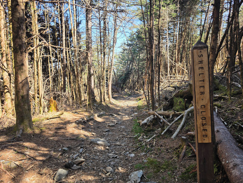
Continuing beyond Cloudland, the trail becomes wide and forgiving, climbing gradually toward Roan High Knob. After several miles of rolling terrain, the nearly flat, shaded stretch through dense pine and fir forest feels like a welcome reprieve. Eventually, I reach the spur trail to the Roan High Knob Shelter, the highest shelter on the entire Appalachian Trail at 6,285 feet. Although a sign along the AT indicates that it's closed, I take the short detour to check it out. Extensive repairs are underway—likely due to Helen storm damage—with work being done on the foundation, walls, and roof. There are no views from the shelter, but it’s a worthwhile stop for those interested in notable AT landmarks. I've been told that there is a water pipe up here somewhere, but I can't find it—possibly another casualty of the hurricane.


From Roan High Knob, the trail descends gently for several miles through continuous spruce-fir forest, making for an unexpectedly easy approach toward Carver’s Gap.

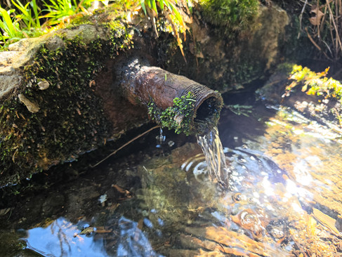
Just before reaching the gap, the trail turns sharply left and drops through a beautifully maintained section, crossing two wooden footbridges just before the road. Near the second bridge, a small marker indicates a nearby water source. Following a tip from a thru-hiker named Muskrat, I find a reliable pipe spring just a short distance downhill along a blue-blazed path. I refill here and continue on.


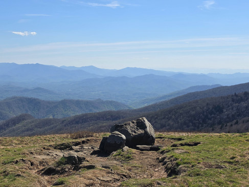
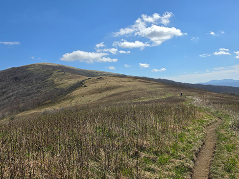
Arriving at Carver's Gap marks a dramatic shift in the landscape. The dense forest gives way to wide-open views. From here, the trail is fully exposed, with no shade and intense sun—something to seriously consider when planning a Roan Highlands backpacking gear list (sunscreen). A short climb leads to Round Bald, where 360-degree views reveal an endless sea of peaks. On a clear day, you can spot distant landmarks like Mount Mitchell, along with other prominent summits stretching across Tennessee, North Carolina, and even into Virginia. The southern-facing views into North Carolina are especially amazing—arguably some of the best scenery in the Roan Highlands. Photos do no justice.


From Round Bald, the iconic grassy summits of Jane Bald and Grassy Ridge Bald rise just ahead. After a quick break to take in the views, I continue north. The climb up Jane Bald is short but surprisingly demanding, with a steep, rocky pitch that feels like one of the more challenging sections I've encountered over 40+ miles of hiking in the Highlands.


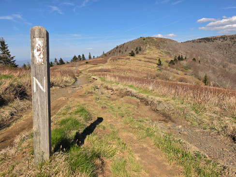


At the top of Jane Bald, I notice a faint, hiker-made spur trail leading back toward Round Bald. Since I had planned on camping somewhere between Jane Bald and Grassy Ridge Bald, I follow it—and it turns out to be one of the best decisions of the trip so far. The short path, maybe 150 feet long, opens to a small campsite with unobstructed, 360-degree views of Round Bald, Roan High Knob, Grassy Ridge Bald, and an endless panorama of Blue Ridge peaks. I think to myself - there can't be a better backcountry site anywhere in the Roan Highlands. I drop my pack, slug down a liter of water, and enjoy the incredible views. About an hour before sunset, temperatures begin to fall and the wind picks up across the exposed bald. I set up camp and watch the sun slowly dip below the horizon over one of the most beautiful stretches of the Appalachian Trail that I've ever encountered. Again, photos do absolutely zero justice.


After a wildly windy night on Jane—punctuated by the sound of howling coyotes—I wake to a glowing sunrise spilling over the shoulder of Grassy Ridge Bald. With a long day of hiking ahead, I break down camp and hit the trail.


Just a few hundred feet from camp, I pass the spur trail to the summit of Grassy Ridge Bald, but decide to stay on the AT. I'm out of water, and without knowing where water is ahead, the extra mileage up to the summit of Grassy Ridge Bald isn't in the cards.

Thankfully, less than a quarter mile later, I reach a pipe spring right along the right side of the trail. It's impossible to miss. I fill up two liters of water, then continue along the singletrack with the sun beginning to break through the clouds. Next time I'm around, I'll make sure to hit the summit of Grassy Ridge Bald.


The gradual descent from Grassy Ridge Bald reveals several established campsites, each suitable for several tents, and roughly two miles from camp, I arrive at the Murray Shelter, a popular stop for AT thru-hikers. I hook up with a few thru hikers I met the day before, and one of them shares some leftover trail magic before I push on. “Whoever dropped off a case of Heineken and Coke at the shelter last evening is going to heaven,” one of them says.


After a short climb from the shelter, the trail levels out into a flat stretch filled with wildflowers - violets and Blue Ridge Phacelia, I believe.


About two miles past Stan Murray Shelter, I reach Yellow Mountain Gap and take a quick detour to explore the Overmountain camping area. A short spur trail leads downhill past another pipe spring to a wide-open camping area with sweeping views of Roaring Creek Valley, Yellow Mountain, and various other peaks. The Overmountain Shelter, also known as Yellow Mountain Barn, once stood here but it was closed in 2019 and finally taken down piece by piece in November 2023 due to severe structural instability. It's name was derived from the Overmountain Men, American frontier settlers from west of the Blue Ridge Mountains, who passed through the Gap on their way from Sycamore Shoals (now Elizabethton), Tennessee to defeat the British Army under Major Patrick Ferguson at the Battle of Kings Mountain (South Carolina) during the Revolutionary War. The defeat freed the American South from British domination, and was a major turning point in the war. The barn was one of the largest shelters on the AT, with a capacity for at least 35 people. Although the shelter is no longer standing, the area remains one of the best and most popular backcountry camping spots in the Roan Highlands. Great views, a reliable water source nearby, and plenty of room for thru hikers and weekend warriors alike.


Back on the AT. The climb out of Yellow Mountain Gap is relentless—steep, sustained, and arguably tougher than the ascent up Jane Bald earlier in the trip. I break often, not just to catch my breath, but to take in the sweeping views behind me, including Roan High Knob, Round Bald, Grassy Ridge Bald, and more of Roaring Creek Valley.


Eventually, the climb leads me to Little Hump Mountain, where I’m rewarded with some of the best 360-degree views in the Highlands. Behind me, the familiar balds stretch across the horizon, while ahead lies the imposing Hump Mountain, with Grandfather Mountain visible in the distance. Many hikers consider the views from Little Hump to be the best in the Roan Highlands—and it’s hard to argue.


From Little Hump, I descend into Bradley Gap, where I find a few campsites followed by a marker on a tree indicating a water source below. No more than thirty feet off trail is a small, natural spring with minimal flow—likely unreliable in warmer months.

With no need to refill, I keep moving. Not long after, I break out of the forest at the base of Hump Mountain, where I stop for a water break and watch a loose line of backpackers climbing the bald. Then I move on, pushing into the same relentless winds I felt on Little Hump, stopping now and then to catch my breath and take in the views.


After pushing past a false summit, I reach the top of Hump and break to soak it all in. The panoramic 360-degree views are breathtaking and easily among the best on the entire route. From the summit, I can pick out Little Hump Mountain, Grassy Ridge Bald, Round Bald, Roan High Knob, Yellow Mountain, and even Mount Mitchell—but they’re just a handful among the hundreds of peaks stretching to the horizon. It's spectacular.


I chat briefly with a father and son, snap a few photos, and then begin the descent along Houston Ridge. The ridgeline offers continuous views, including a persistent sightline to Grandfather Mountain—one of North Carolina’s most recognizable peaks and a personal favorite of mine. A few years back, I found a plane crash up on Grandfather, which was pretty interesting.

Shortly into the descent, I stop not out of exhaustion, but simply to sit and take in the landscape. This is one of the most beautiful sections of the Roan Highlands in my opinion, and I want to remember it. With the sun beating down, I set off again, slowly descending the grassy ridge while taking in the sweeping views ahead. I pause to collect a bit of the ridge’s grass to bring home in a small glass vial. It’s a tradition of mine to gather soil from places I love and keep it as a reminder—but here, grass feels more fitting than dirt. A few miles later, I reach Doll Flats and cross back into Tennessee. The area offers plenty of campsites and even a pipe spring (just after the "Leaving NC" sign), but with just a few miles left to hike, I skip the refill and keep moving.

Eventually, the trail dips back into the forest, where the terrain becomes rough and unforgiving—littered with exposed roots and jagged rocks reminiscent of Pennsylvania sections of the AT. It’s tough on the knees and ankles, but by this point, the views have already made the effort worthwhile. After a couple more miles of forested terrain, I reach 19E, say goodbye to a few of the AT thru hikers that I've been talking with over the last 20 miles, and take a short road walk back to Mountain Harbour.

The journey may be over, but the experience will stick with me for a lifetime. This I'm sure of. While the early days had their challenges and few views, the stretch from Carver’s Gap to Hump Mountain is nothing short of world-class backpacking—arguably one of the most scenic sections of the entire AT. The Roan Highlands didn’t just meet my expectations—they exceeded them. And next time, I’ll be back… hopefully with Heather by my side.


