_edited.png)
Avalanche Lake: A Classic Glacier National Park Hike with Big Views
Updated: Sep 8
Hiking the Avalanche Lake Trail is one of the best ways to experience the park's spectacular west-side scenery without committing to an all-day adventure. Beginning along the famous Trail of the Cedars, the route travels through an ancient forest of western red cedars and hemlocks, passes the rushing turquoise water of Avalanche Creek, and climbs into a dramatic glacial basin surrounded by towering mountains and waterfalls. At roughly 7 miles round trip, the hike to Avalanche Lake offers one of the best scenery-to-effort ratios in Glacier National Park, which also makes it one of the park's most popular hiking trails.

Trail Info
Length 7 miles
Elevation gain 705 feet
Route Loop
Permit required no
Dogs allowed no
Trailhead elevation 3,402'
Water filterable from Avalanche Creek and lake
Don't miss going to the back side of the lake for some of the best views
Hiking to Avalanche Lake
The hike to Avalanche Lake begins at the Avalanche Picnic Area along Going-to-the-Sun Road, near Avalanche Campground and roughly midway between Apgar and Logan Pass. Parking is available around the Avalanche area, but hikers shouldn't count on finding a space easily during the park's busy season (July through Labor Day). Avalanche Creek is one of the most heavily visited areas in Glacier National Park, and the parking areas can become extremely busy. Parking can accommodate roughly 30 vehicles and often fills to capacity by 7 AM. The nearest overflow parking can be found more than a mile north along Going-to-the-Sun Road near Red Rock Point.

Rather than immediately beginning on the Avalanche Lake Trail, hikers first follow a portion of the Trail of the Cedars, a 1-mile nature loop through one of the most unusual forests in Glacier National Park. The lower Avalanche Creek drainage receives enough moisture that the landscape feels more like something found in the Pacific Northwest than the northern Rocky Mountains. Towering western red cedars and western hemlocks shade the boardwalk, while ferns and other moisture-loving plants blanket the forest floor. Some of the western red cedars growing around Avalanche Creek are more than 500 years old, and Glacier National Park marks the extreme eastern edge of the species' range in the United States. It's an impressive start to the hike and one worth slowing down to appreciate, even for hikers primarily interested in reaching Avalanche Lake.

Roughly halfway around the Trail of the Cedars, hikers reach a footbridge spanning Avalanche Creek and one of the most beautiful sections of the hike. Below the bridge, the creek surges through Avalanche Gorge, where centuries of rushing water have carved and polished the colorful rock into smooth, twisting walls. Moss clings to the shaded gorge while the blue-green water funnels through the narrow channel below.

Just beyond the gorge, hikers leave the Trail of the Cedars and turn onto the Avalanche Lake Trail, which is where the hike really begins.

From the junction, the Avalanche Lake Trail immediately begins climbing through the forest alongside Avalanche Creek. The ascent is steady rather than particularly steep, making this a relatively approachable hike compared with many of Glacier National Park's longer mountain trails.

As the trail gains elevation, the vegetation gradually changes. The enormous cedars and hemlocks of the lower drainage begin giving way to a mixed forest dominated by spruce and fir. Avalanche Creek remains nearby for much of the climb, occasionally appearing through openings in the trees as it tumbles over boulders and through the forest.

Although the hike remains heavily forested, occasional openings provide glimpses of the mountains surrounding the drainage, including Bearhat Mountain, which rises to approximately 8,684 feet. The combination of dense forest, rushing water, mountain views, and relatively moderate climbing is a big reason the Avalanche Lake Trail has become one of the most popular hikes in Glacier National Park.

Eventually, the terrain begins to level and the forest starts to open. Massive cliffs suddenly appear ahead through the trees, signaling that hikers are approaching Avalanche Basin. After spending most of the hike surrounded by dense forest, the first glimpse into the basin provides one of the most memorable moments along the Avalanche Lake Trail. Soon afterward, hikers emerge from the trees at the northern shore of Avalanche Lake, sitting at roughly 3,900 feet above sea level beneath an enormous glacially carved amphitheater.
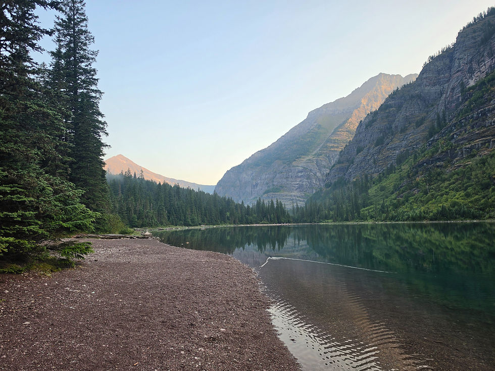
It's a spectacular setting. Steep mountain walls rise dramatically around three sides of the lake, while numerous waterfalls pour from the cliffs at the head of the basin. Little Matterhorn, which rises along the ridge south of the lake, is one of the basin's most distinctive summits. The waterfalls spilling into Avalanche Basin are arguably what separates Avalanche Lake from many of Glacier National Park's other alpine lakes. Rather than a single waterfall, hikers are greeted by a collection of long, slender cascades dropping hundreds of feet down the cliffs at the far end of the lake. Their volume varies throughout the year, with the waterfalls typically looking especially impressive during late spring and early summer when mountain snowmelt is at its peak.


Some of this water originates from the Sperry Glacier drainage, hidden in the high country beyond the cliffs. Melting snow and ice from the high country feed the enormous waterfalls cascading down the back wall of the cirque during the summer. One of the commonly identified cascades in the basin is Monument Falls, which carries meltwater from the high country above Avalanche Lake. Although Sperry Glacier itself cannot be seen from Avalanche Lake, it lies beyond the ridgeline above the basin and has played an important role in both the landscape and human history of this part of Glacier National Park.
Avalanche Lake's name dates back to the earliest period of exploration in what would eventually become Glacier National Park. In 1895, Dr. Lyman Beecher Sperry named Avalanche Lake and Avalanche Creek after observing the enormous avalanche tracks descending the surrounding mountainsides. Those avalanche paths remain an obvious feature of the basin today and demonstrate just how active this landscape can be during winter and spring. Sperry was a professor at Oberlin College in Ohio and became one of the important early explorers of the region. During an expedition into Avalanche Basin in 1894, he noticed the milky appearance of the water flowing into Avalanche Lake and correctly suspected that a glacier existed somewhere in the mountains above.

Sperry and members of his party climbed the cliffs at the head of Avalanche Basin and eventually reached a vantage point near Little Matterhorn, where they could see the glacier hidden above the lake. The glacier would later become known as Sperry Glacier in his honor. That history gives hikers standing along Avalanche Lake an interesting connection to Glacier's early exploration. More than a century ago, Sperry stood in essentially the same basin, looked at the sediment-rich water entering the lake, and realized that a large glacier must be hidden somewhere in the mountains overhead.

Many hikers reach the first beach at Avalanche Lake, take a few photos, and turn around, but those with extra time should consider continuing. A trail follows the western shoreline for roughly another 0.7 mile toward the head of Avalanche Lake, providing different perspectives across the water and bringing hikers closer to the waterfalls descending from the surrounding cliffs. Continuing along the shoreline also provides a chance to escape at least some of the crowds congregating near the lake's first viewpoint.

From farther along the lake, hikers can better appreciate the scale of Avalanche Basin. The towering cliffs dominate the skyline while waterfalls streak down the rock walls ahead. Looking back toward the outlet also provides an entirely different perspective of the lake and surrounding mountains. For photographers, exploring beyond the first beach can be well worth the additional mileage.

Once hikers are finished exploring Avalanche Lake, the return trip is simple: retrace the route back through the forest toward Avalanche Creek. Because most of the elevation gain occurred on the hike toward the lake, the return is predominantly downhill and tends to go considerably faster. After reaching the junction with the Trail of the Cedars, hikers can complete the remaining portion of the nature loop rather than simply returning the way they came. Doing so provides another walk beneath the massive western red cedars before eventually arriving back at the Avalanche Picnic Area and Going-to-the-Sun Road.

The Avalanche Lake Trail is generally considered a moderate hike, although experienced hikers may find it relatively easy compared with many of Glacier National Park's longer trails. The route gains elevation gradually, and there are no major exposed sections, mountain passes, or exceptionally steep climbs. That makes Avalanche Lake an excellent choice for families, casual hikers, and visitors searching for a shorter hike that still delivers classic mountain scenery.
Early summer generally produces the most impressive waterfalls thanks to snowmelt pouring out of the high country, while later summer usually provides warmer weather and a greater chance of a completely snow-free trail. The biggest challenge isn't necessarily trail conditions—it's crowds. Avalanche Creek is one of the busiest destinations in Glacier National Park, so hikers hoping for a quieter experience should consider arriving very early in the morning or hiking later in the day. Early starts also improve the odds of finding parking and provide cooler temperatures for the climb.
There are bigger mountains, longer trails, and more remote alpine lakes scattered throughout Glacier National Park, but few hikes pack as much variety into such a manageable distance as the Avalanche Lake Trail. Within roughly 7 miles, hikers experience the old-growth forest of the Trail of the Cedars, the rushing water and colorful rock of Avalanche Gorge, the lush forests surrounding Avalanche Creek, towering Rocky Mountain peaks, a beautiful alpine lake, and a spectacular collection of waterfalls pouring into a glacier-carved basin. It's also a hike with a fascinating connection to Glacier National Park's early exploration. Standing along the shore of Avalanche Lake and looking toward Little Matterhorn and the waterfalls spilling from the mountains, hikers are looking into the same basin that led Lyman Sperry into the high country in search of the glacier that would eventually bear his name. For first-time visitors searching for the best hikes in Glacier National Park, families looking for a moderate adventure, or anyone exploring the west side of Going-to-the-Sun Road, hiking to Avalanche Lake deserves a spot near the top of the list.


Comments