_edited.png)
Backpacking Cuyahoga Valley National Park
Backpacking in Cuyahoga Valley National Park comes with one major catch: overnight camping isn't permitted within the park. Still, with more than 125 miles of trails winding through forests, rolling hills, and river valleys, you can piece together a legitimate overnight or multi-day adventure. The key is planning each day to end at a campground just outside of the park or a privately owned accommodation within the park before returning to the trail the next morning. It requires a little extra planning, but it's possible to experience some of CVNP's most scenic stretches with a pack on your back.

Trail Info
Length 19 miles
Elevation gain 1,950 feet
Route Loop
Permit required Yes, for backcountry camping
Dogs allowed On leash
Trailhead elevation 865'
Water Throughout
Don't miss Sunrise along the Valley Bridle Trail
Backpacking Cuyahoga Valley National Park
With limited route options that can accommodate an overnight stay, one of the best ways to backpack through Cuyahoga Valley National Park is by linking the Brandywine Gorge, Stanford, Buckeye, and Valley Bridle Trails into a roughly 19-mile loop. The route includes an overnight stay just outside the park boundary at the Ottawa Overlook Backcountry Sites in neighboring Brecksville Reservation. Along the way, hikers visit three of Cuyahoga Valley’s most scenic waterfalls—Brandywine Falls, Blue Hen Falls, and Buttermilk Falls—while also traveling through more secluded corners of the park that see far fewer visitors. There really isn’t a bad time of year to tackle the loop, although late summer and fall are especially beautiful. Hiking clockwise is recommended.
The route begins at the Brandywine Falls parking area near the heart of the park. From the trailhead, a short walk along the boardwalk follows the rim of the hemlock-filled Brandywine Gorge before descending to an observation deck overlooking the 60-foot Brandywine Falls.

After returning to the trailhead, hikers pick up the Brandywine Gorge Trail and head west beneath a dense canopy of hardwoods. Modest elevation changes make this opening stretch a nice warm-up for the miles ahead.

Less than a mile and a half into the hike, the trail passes behind the historic Stanford Farm, offering a glimpse into Cuyahoga Valley’s agricultural past. The property's history dates to 1806, when early settler James Stanford acquired the land. His son George built the Greek Revival-style Stanford House around 1843, while the surrounding farm eventually grew to nearly 300 acres and included barns, fields, orchards, and livestock. Today, the restored house and historic barn remain prominent reminders of the families who farmed this land long before it became part of Cuyahoga Valley National Park.

Behind the barn, hikers connect with the Valley Trail and head south, briefly paralleling Stanford Road before reaching Boston Mills Road. Here, the historic Boston Store sits beside the Towpath Trail near the Cuyahoga River. Once the park’s primary visitor center, the Boston Store now serves as a convenient stop for hikers and cyclists passing through Boston Mills, offering ice cream, cold drinks, grab-and-go food, snacks, and park souvenirs.

From the Boston Store, continue a short distance along Boston Mills Road and cross the Cuyahoga River to reach the Boston Mill Visitor Center at roughly 2.6 miles. The park’s main visitor center is a good place to top off water, chat with a ranger, and learn more about the history of Cuyahoga Valley National Park, the most visited national park in the Midwest. For hikers interested in shortening the overall route, the visitor center also makes a convenient alternate starting point.

Just outside the visitor center, at the southwest corner of Riverview and Boston Mills Roads, the route connects with the blue-blazed Buckeye Trail—Ohio’s signature long-distance trail, stretching more than 1,400 miles around the state.

Over the next mile and a half, the trail repeatedly rises and falls, descending steep staircases and crossing footbridges over small streams before reaching Blue Hen Falls around the 4.1-mile mark. One of the park’s most photographed landmarks, the 15-foot waterfall spills over a broad sandstone ledge along Spring Creek. It's a nice spot to stop and relax for a few minutes before moving on.

A worthwhile side trip from Blue Hen Falls leads to Buttermilk Falls, an unofficial but beautiful waterfall farther downstream along Spring Creek. To reach it, continue beyond the “End of Trail” sign above Blue Hen Falls and follow the well-worn unofficial path for roughly 0.4 miles. The route crosses Spring Creek several times, but outside of periods of high water, the crossings generally involve little more than easy rock hopping.

After returning to Blue Hen Falls, the route changes direction and begins heading north along the Buckeye Trail. This far less traveled stretch passes above steep ravines, winds through stands of hemlocks, and eventually reaches a shallow stream crossing around the 5.3-mile mark. While this stretch lacks the dramatic scenery found elsewhere in the park, it offers something equally rewarding: a welcome dose of solitude, especially after leaving behind the crowds at Brandywine and Blue Hen Falls.

The stream crossing can be surprisingly easy to miss, and hikers who continue straight may soon find themselves at a dead end. The best advice: after passing through the first stand of hemlocks and descending toward the stream, look for the rock formation shown in the photo below, which marks the crossing. During spring or after periods of heavy rain, the water can reach calf depth, while during the warmer and drier months it can usually be crossed by rock hopping.

Near the 6-mile mark, the Buckeye Trail crosses Columbia Road before continuing north. The route later crosses Snowville Road at approximately 8.2 miles. Because dependable water sources become increasingly scarce beyond Spring Creek and Blue Hen Falls, these road crossings can be useful locations for caching water ahead of the hike.
At Snowville Road, the route veers left for roughly 50 yards before entering a wetland, where a series of boardwalks carry hikers through native grasses and seasonal wildflowers.

While crossing the first boardwalk, look to the right for two yellow buildings. Today they serve as park administration buildings, but decades ago they housed workers associated with the historic Jaite Paper Mill community.

After roughly a third of a mile, the trail reenters the forest and climbs a short but steep incline before continuing north along a narrow singletrack beneath a dense hardwood canopy. Between Snowville Road and the Ottawa Overlook Backcountry Sites, hikers cross four unnamed streams. Most are easily negotiated with a little rock hopping, and none should be relied on as dependable water sources.

Around 11.5 miles, the Buckeye Trail merges with the yellow-blazed Valley Bridle Trail. Roughly a mile later, hikers arrive at the Ottawa Overlook Backcountry Sites in Brecksville Reservation.

There are three well-marked primitive campsites, spaced roughly 100 yards apart. Sites 1 and 3 offer the most seclusion, while Site 3 includes a wooden tent platform and Sites 1 and 2 have dirt tent areas. There is no electricity, and fires are not permitted at the campsites. The sites themselves don't offer much in the way of scenery, but they provide a peaceful place to spend the night before beginning the return trip. A free permit is required and can be reserved in advance through Cleveland Metroparks.

The campsites sit roughly 100 yards from the Ottawa Point Picnic Area, where hikers will find restrooms, a water fountain, picnic tables, grills, and a pavilion with a fireplace. There is also a great outdoor fire pit surrounded by wooden Adirondack chairs. Since fires are prohibited at the backcountry sites themselves, hikers hoping to enjoy one in the evening should arrange (one their own) to have firewood waiting near the pavilion before beginning their hike.

The following morning, retrace your steps to the junction of the Buckeye and Valley Bridle Trails. From here, remain on the Valley Bridle Trail, which provides a considerably shorter return route toward Brandywine Falls.

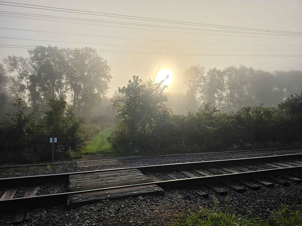
Near the 14.2-mile mark, the trail crosses Riverview Road and transitions onto a grassy path. This open stretch is particularly beautiful in the morning, when the rising sun begins clearing the surrounding trees roughly 30 minutes after sunrise.

Wildflowers line portions of the grassy corridor, making this one of the more scenic and peaceful stretches of the entire route.


About half a mile later, the trail passes an abandoned barn tucked beside the path, another silent reminder of the many farms that once occupied much of the Cuyahoga Valley.

Less than half a mile beyond the barn, the Valley Bridle Trail crosses the tracks of the Cuyahoga Valley Scenic Railroad and soon begins paralleling the Cuyahoga River.

Around the 16-mile mark, the trail reaches Vaughn Road. Cross the Cuyahoga River here and pick up the Towpath Trail just south of the Red Lock Trailhead. Not far beyond the junction, the Towpath passes the former site of the Jaite Paper Mill. Once the industrial heart of a small company town, the mill site is now fenced off and largely reclaimed by vegetation.

A short distance later, leave the Towpath and reconnect with the Valley Bridle Trail for the final stretch toward Brandywine Falls.

Around the 17-mile mark, the trail reaches Stanford Road. Turn left and follow the road for a little more than half a mile until it intersects with the Brandywine Gorge Trail.

Turn left onto the Gorge Trail, cross the long footbridge spanning Brandywine Creek, and begin the final push back toward Brandywine Falls.

From here, the sound of rushing water accompanies much of the remaining hike. Just before the final climb, a beautiful view of Brandywine Creek appears, offering one last look at the water before it disappears beneath the surrounding hemlocks and hardwoods.

The final ascent is brief but moderately steep, eventually reaching a paved all-purpose trail. From here, the route passes the historic Inn at Brandywine Falls before crossing above the crest of the waterfall and returning to the Brandywine Falls parking area.

After roughly 19 miles, three waterfalls, dense forests, historic farms, wetlands, river crossings, and a night beneath the trees, the loop comes to an end right where it began—at one of Cuyahoga Valley National Park’s most iconic landmarks.


Comments