Best Hike in the Columbia River Gorge? Eagle Creek to Tunnel Falls Makes its Case
- Dan Wagner

- 2 days ago
- 9 min read
Few hikes in the Columbia River Gorge deliver as much scenery, history, and adventure as the Eagle Creek Trail to Tunnel Falls. Widely considered one of the best waterfall hikes in Oregon, the unforgettable trek follows the crystal-clear waters of Eagle Creek through a dramatic basalt canyon lined with towering cliffs, old-growth forest, and a seemingly endless series of waterfalls. Along the way, hikers pass iconic landmarks like Punch Bowl Falls, High Bridge, and several cliffside sections carved directly into the canyon walls before reaching the hike's crown jewel: the spectacular 172-foot Tunnel Falls, where the trail passes through a tunnel blasted behind the roaring waterfall. Combining breathtaking scenery, unique trail engineering, and one of the most memorable waterfall experiences in the Pacific Northwest, the Eagle Creek Trail to Tunnel Falls is a bucket-list hike that belongs on every Columbia River Gorge itinerary.

Trailhead elevation 127'
Water at Lower Punch Bowl Falls and various points along Eagle Creek
Don't miss Twister Falls
Hiking Eagle Creek to Tunnel Falls
The hike to Tunnel Falls begins at the Eagle Creek Trailhead, one of the most popular trailheads in the Columbia River Gorge, located just minutes from I-84 near Cascade Locks. The main parking area accommodates roughly 20 vehicles, with an overflow lot located about a half-mile before the trailhead. Both lots often fill early, especially on weekends and throughout the summer hiking season, so arriving early is highly recommended. A day-use permit is required to hike the Eagle Creek Trail and can be purchased at the self-service kiosk near the trailhead.

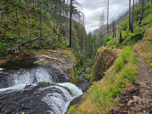
From the parking area, the Eagle Creek Trail immediately follows the crystal-clear waters of Eagle Creek, crossing a small footbridge before beginning a gradual climb into the heart of Eagle Creek Canyon. The easy grade offers a deceptively gentle introduction to one of the most spectacular hikes in the gorge, as towering Douglas firs, moss-covered cliffs, and the constant sound of rushing water quickly immerse hikers in one of Oregon's most iconic landscapes.


Few hiking trails in the Pacific Northwest can match the history of the Eagle Creek Trail. Constructed between 1916 and 1917 during the development of the Historic Columbia River Highway, the trail was an engineering marvel of its time. Workers blasted narrow ledges directly into towering basalt cliffs, creating a route that hugged the canyon walls rather than climbing above them. Just before the one-mile mark, hikers encounter the first of the trail's famous cable sections, where sturdy steel hand cables are anchored into the rock to provide reassurance as the path traverses dramatic cliffs with drops of hundreds of feet to Eagle Creek below.


Although the first few miles of the Eagle Creek Trail are often the busiest—thanks to visitors making the shorter hike to Punch Bowl Falls—the scenery is immediate. Thick blankets of moss drape the basalt walls, springs seep from the cliffs overhead, and countless small streams spill across the trail. Long before reaching the area's famous waterfalls, Eagle Creek Canyon reveals why it has endeared hikers for generations. The sound of Eagle Creek is a constant companion, alternating between a gentle murmur beneath the forest canopy and a thunderous roar as the creek funnels through narrow volcanic chasms carved deep into the canyon.

Around the 1.1-mile mark, the trail rounds a bend, revealing one of the first truly remarkable viewpoints of the hike. Down the canyon, the 80-foot Metlako Falls plunges into the narrow gorge, while nearby Sorenson Falls tumbles nearly 100 feet down the opposite canyon wall. Although the official overlook and spur trail to Metlako Falls remain closed due to unstable terrain caused by a 2016 cliff collapse and further damage from the 2017 Eagle Creek Fire, the views from the main trail are still impressive. Ironically, the wildfire also transformed the landscape in an unexpected way. Before the fire, dense old-growth forest almost completely concealed Sorenson Falls from view. With much of the canopy burned away, hikers can now enjoy a clear view of the waterfall's lower tier—a rare silver lining from one of the Columbia River Gorge's most destructive wildfires.


Around half a mile later, the trail intersects with the marked Lower Punch Bowl Falls spur trail. The spur descends steeply about 300 feet over 0.2 miles to Eagle Creek where hikers are greeted by views of Lower Punch Bowl Falls framed by towering cliffs and, in recent years, a massive logjam left behind by a 2018 landslide. Before the landslide, adventurous hikers could often continue upstream by carefully crossing Eagle Creek to reach the famous river-level viewpoint of Punch Bowl Falls. Today, however, the landslide dramatically altered the Canyon, depositing enormous boulders and trees that changed the creek's course and made access to the classic lower viewpoint far more difficult and often unsafe depending on water levels.


Less than 0.1 miles beyond the spur, the trail reaches Punch Bowl Falls, one of the most iconic waterfalls in the Columbia River Gorge. Though it stands only about 35 feet tall, Punch Bowl Falls is far more famous for its shape and setting than its size. Here, Eagle Creek is funneled through a narrow notch in the basalt before plunging into a nearly circular amphitheater, forming the deep, rounded basin that gives the waterfall its name.

Punch Bowl Falls is so distinctive that it helped define an entire waterfall classification. The term “punchbowl waterfall” is now commonly used to describe waterfalls that drop into a broad, rounded pool after passing through a narrow rock constriction. While the falls remain one of the signature landmarks along the Eagle Creek Trail, the surrounding canyon has changed dramatically in recent years. The 2017 Eagle Creek Fire did not destroy the waterfall itself, but it did destabilize the slopes above Eagle Creek.


Today, reaching a head-on view of Punch Bowl Falls is more difficult than it once was, but even from the main trail, the waterfall remains one of the most memorable sights on any hike through Eagle Creek Canyon.

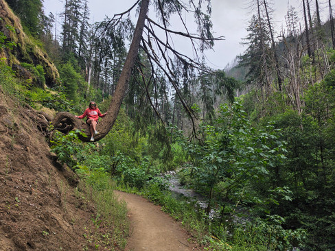
Beyond Punch Bowl Falls, the crowds tend to thin considerably. The Eagle Creek Trail continues its gradual climb deeper into Eagle Creek Canyon, with Eagle Creek rarely leaving sight or earshot. Over the next quarter mile, the trail winds through one of the areas most heavily impacted by the 2017 Eagle Creek Fire, where blackened tree trunks still stand among thriving new vegetation, offering a striking reminder of the wildfire that forever reshaped the canyon. Along the way, hikers cross a modest footbridge and through a large rockslide before following the trail across narrow ledges that have made the Eagle Creek Trail famous.


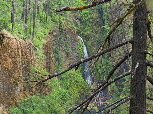
Around the 3-mile mark, the trail passes above Loowit Falls, a beautiful 90-foot, two-tiered waterfall that free-falls down the opposite wall of Eagle Creek Canyon. The waterfall is named after Loowit, a revered figure in Native traditions of the Columbia River Gorge. According to one legend, Loowit, an elderly woman, tended sacred fire on the Bridge of the Gods before being transformed into the mountain now known as Mount St. Helens, which many Indigenous peoples have long called Loowit.


No more than 0.2 miles later, the trail rounds a corner and High Bridge comes into view, spanning one of the narrowest and most dramatic sections of Eagle Creek Canyon. After another narrow, cable-assisted traverse along sheer cliffs, the trail reaches the iconic crossing, where hikers can look straight down as Eagle Creek races through a deep basalt chasm more than 150 feet below.


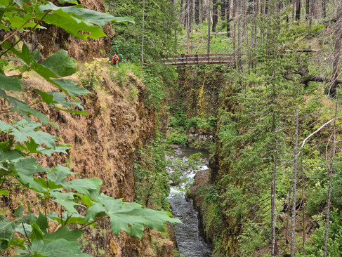
Before High Bridge was built, hikers crossed Eagle Creek on a lower wooden bridge that was repeatedly damaged or washed away by floods. Following the Eagle Creek Fire, the current steel-and-timber bridge was flown into the canyon by helicopter and installed as part of the trail’s restoration. Today, High Bridge is one of the most memorable landmarks along the Eagle Creek Trail and marks a dramatic transition between the lower canyon and the wilder stretch leading toward Tunnel Falls.


Beyond High Bridge, the trail continues its gentle climb through Eagle Creek Canyon. Within a tenth of a mile, Skoonichuk Falls comes into view, dropping 50 feet in two tiers along the far side of the canyon. Before the Eagle Creek Fire, the falls was mostly visible from High Bridge, but the opened canopy now gives hikers a closer, clearer view than in the past. Its name is believed to come from the Chinook language and is commonly interpreted as meaning “evil spirit,” or as a reference to a supernatural spirit associated with the water.


From there, the trail meanders deeper into the canyon, passing overgrown stretches of invasive vegetation and large boulders scattered along the west side of the creek. A short distance later, hikers arrive at 4-1/2 Mile Bridge. Despite the name, the bridge sits closer to 4 miles from the modern trailhead. In the 1930s, during the realignment of the Historic Columbia River Highway and the construction of Bonneville Dam, the Eagle Creek Trailhead was moved about half a mile upstream. The bridge, however, kept its original name and is still known today as 4-1/2 Mile Bridge.


Just after crossing 4-1/2 Mile Bridge, hikers can spot Tenas Falls a few hundred feet upstream on the far side of Eagle Creek. The 25-foot waterfall spills from an unnamed tributary into the creek below, but this brief glimpse is usually the best view hikers will get, as thick foliage along the trail quickly obscures it. Its name comes from the Chinook Wawa (Chinook Jargon) word for “small,” a fitting choice for one of the more modest waterfalls along Eagle Creek.

Beyond Tenas Falls, the canyon grows noticeably narrower as the creek tumbles through an increasingly boulder-strewn channel and the trail begins a steeper climb toward Tunnel Falls.


Around the 5.6-mile mark, the trail rounds another bend and traverses a series of cliffs overlooking Grand Union Falls, a 55-foot waterfall plunging into a nearly circular emerald pool below. The waterfall takes its name from the "Grand Union" of Eagle Creek's two forks. Just upstream, the East Fork Eagle Creek—home to Tunnel Falls and Twister Falls—merges with the main stem of Eagle Creek before the combined waters plunge over the falls. This stretch of trail is just as notable for its geology as it is for the waterfall. Known as The Potholes, the area was blasted through thick layers of columnar basalt during the construction of the Eagle Creek Trail. The volcanic rock fractured into an assortment of bowl-shaped depressions and rounded protrusions, creating one of the trail's most distinctive and fascinating sections.

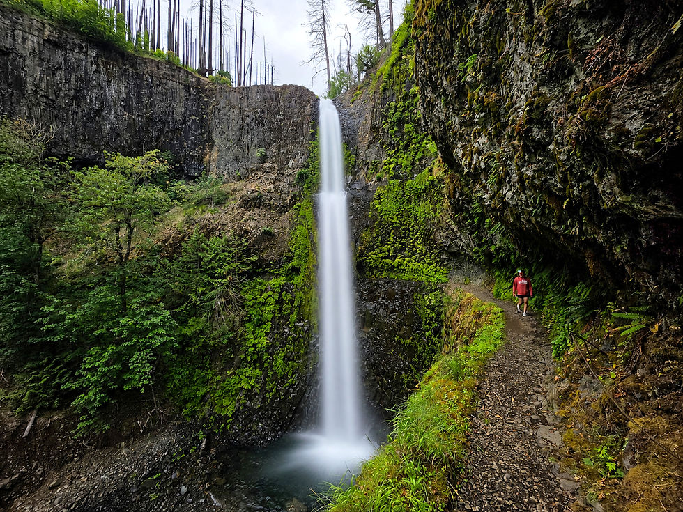
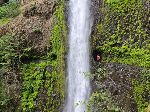
Less than half a mile later, the roar of Tunnel Falls grows impossible to ignore as hikers arrive at what many consider the crown jewel of the Eagle Creek Trail. Plunging 172 feet into Eagle Creek, it is the largest and most impressive waterfall along the hike, and one of the most iconic waterfalls in the Columbia River Gorge.

As hikers approach Tunnel Falls, the trail narrows considerably, at times shrinking to just 2 to 3 feet wide with sheer 100-foot drop-offs below. Those with a fear of heights may find this section particularly intimidating. Hand-blasted through solid basalt by U.S. Forest Service crews during the construction of the Eagle Creek Trail more than a century ago, the tunnel itself is only a few dozen feet long, but passing through it is an unforgettable experience.


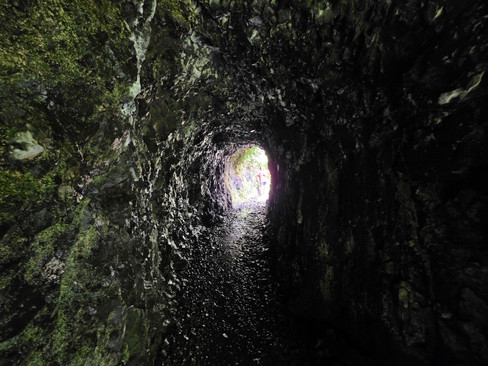


Emerging from the tunnel, hikers immediately encounter the narrowest section of the trail—a ledge protected by a steel cable where Tunnel Falls crashes just a few feet away before plunging into Eagle Creek below. It's an experience unlike almost any other waterfall in the Pacific Northwest and the undisputed highlight of the Eagle Creek Trail.


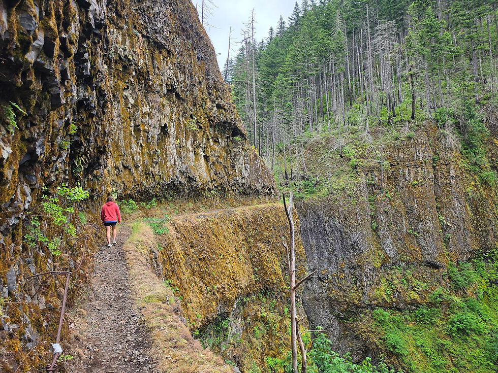
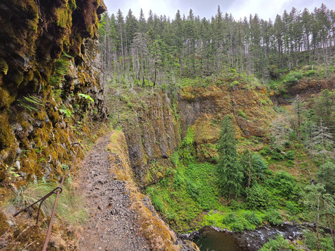
For many hikers, Tunnel Falls marks the turnaround point. Those with a little more energy, however, should continue the short quarter-mile to nearby Twister Falls, a spectacular 150-foot waterfall that serves as a fitting finale to the Eagle Creek Trail. The stretch between Tunnel Falls and Twister Falls is also the longest stretch of exposed hiking on the entire trail. For more than 200 yards, the narrow trail clings to towering basalt cliffs high above Eagle Creek, with steel cables providing added security along the ledges. Hikers with a fear of heights may find this section intimidating, but those who push through are rewarded with one of the trail's most dramatic experiences. In addition to the airy traverse, the route offers breathtaking downstream views of Eagle Creek Canyon that rank among the finest on the entire hike.


Finally, around 6.3 miles into the hike, the trail reaches Twister Falls, the final major waterfall along the Eagle Creek Trail and a worthy reward for those who continue beyond Tunnel Falls. Standing roughly 150 feet tall, Twister Falls is unlike any other waterfall in the canyon. Rather than plunging in a single drop, Twister Falls slides over polished basalt before splitting around a rocky rib into two intertwining cascades that appear to twist around one another before rejoining for a final plunge into the canyon below. The waterfall's distinctive shape makes it one of the most unique and photogenic waterfalls in the Columbia River Gorge.


Whether you turn around at Tunnel Falls or continue on to Twister Falls and beyond, the Eagle Creek Trail delivers one of the most unforgettable hiking experiences in the Columbia River Gorge. From towering waterfalls and hand-carved tunnels to narrow cliffside ledges and lush canyon scenery, few trails pack so much beauty and adventure into a single hike. It's easy to see why the Eagle Creek Trail has earned its reputation as not only the premier hike in the Columbia River Gorge, but one of the greatest waterfall hikes in the United States.


Comments