_edited.png)
The Best Waterfall Hike in Glacier National Park? Baring Falls, St Mary Falls & Virginia Falls

Updated: Sep 8
Hiking to Baring Falls, St. Mary Falls, and Virginia Falls is one of the best waterfall hikes along Going-to-the-Sun Road. Beginning above the eastern shore of St. Mary Lake, the route combines sweeping lake and mountain views with four beautiful waterfalls—Baring Falls, St. Mary Falls, Lower Virginia Falls, and Upper Virginia Falls—while traveling through one of the most scenic portions of the St. Mary Valley. The hike is especially appealing because the scenery changes constantly, transitioning from open hillsides overlooking St. Mary Lake to rushing creeks, recovering forests, and the steep mountain drainage surrounding Virginia Creek. For hikers looking for a relatively moderate adventure that packs several of Glacier National Park's best waterfalls into a single hike, starting from Sun Point makes for an excellent option.

Trail Info
Length 7.1 miles
Elevation gain 890 feet
Route Out & back
Permit required no
Dogs allowed no
Trailhead elevation 4,596'
Water from a spigot at the trailhead and filterable near the waterfalls
Don't miss Upper Virginia Falls
Hiking to Baring Falls, St Mary Falls & Virginia Falls
The hike begins from the large Sun Point parking area along Going-to-the-Sun Road, where hikers will find restrooms, potable water, picnic areas, and access to the Sun Point Nature Trail. The parking area can accommodate roughly 30 vehicles and generally fills to capacity by 9:00 AM during the park's busy season (July through Labor Day).

Before heading toward the waterfalls, hikers should strongly consider making the short walk out onto Sun Point itself. The rocky promontory projects above St. Mary Lake and provides an outstanding view across the water toward the mountains surrounding the St. Mary Valley. It's one of the best viewpoints on the eastern half of Going-to-the-Sun Road and provides a great introduction to the landscape hikers are about to travel through.

Sun Point also has an interesting connection to the early history of tourism in Glacier National Park. Beginning in 1915, the promontory was home to the Going-to-the-Sun Chalets, a sprawling Great Northern Railway complex built as part of the company's network of hotels and backcountry chalets throughout the park. Constructed from stone and logs in a Swiss-inspired architectural style, the complex could accommodate as many as 200 overnight guests. Before Going-to-the-Sun Road existed, visitors generally reached the chalets by boat or horseback, and Sun Point served as an important stopping point for travelers crossing the mountains by trail.

The chalets eventually closed during World War II and never reopened. After years of deterioration, the remaining structures were removed in 1949. Today, little remains to suggest that such a substantial lodge complex once occupied the rocky point, but hikers following the trail toward Baring Falls are essentially walking through a landscape that was once part of Glacier National Park's early horseback transportation network.
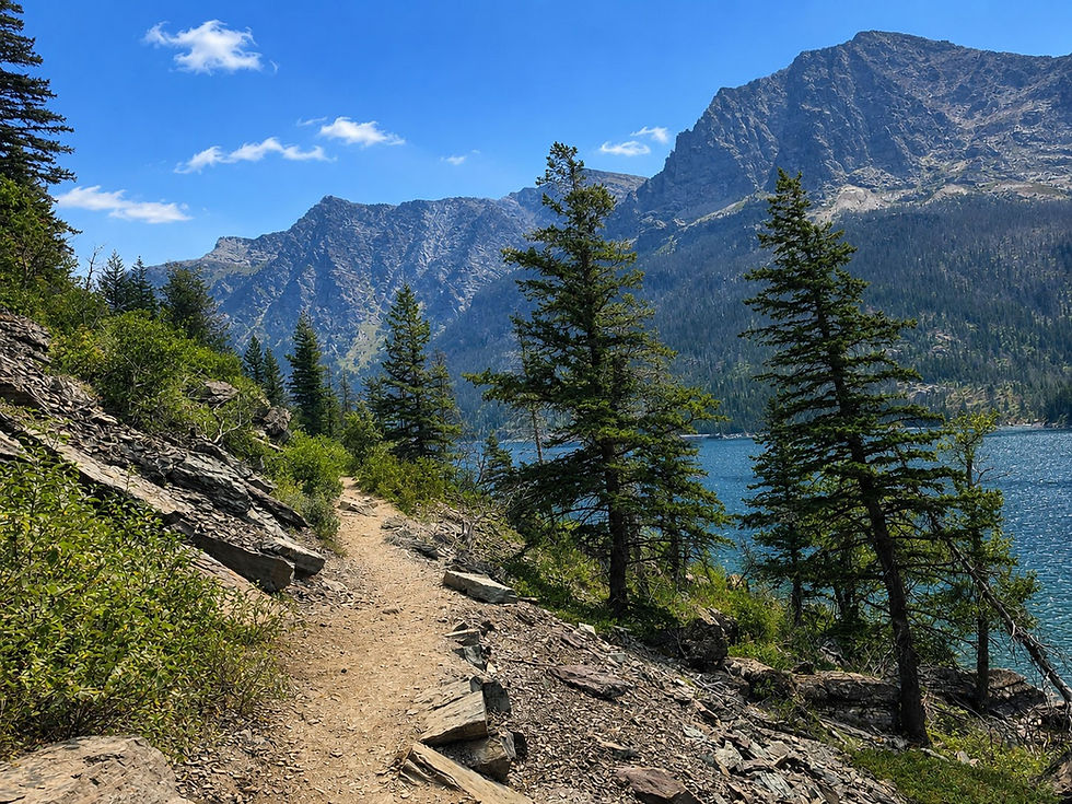
From Sun Point, hikers follow the Sun Point Nature Trail west along the shoreline of St. Mary Lake. This opening stretch is quite different from many of Glacier National Park's heavily forested waterfall trails. Much of the route passes through relatively open terrain, providing frequent views across the lake and toward the rugged mountains surrounding the valley. Depending on the exact location along the trail, some of the prominent mountains dominating the greater St. Mary landscape include Little Chief Mountain, Dusty Star Mountain, Mahtotopa Mountain, and Going-to-the-Sun Mountain.

After roughly 0.8 mile, hikers reach the first major destination of the day at Baring Falls. Here, Baring Creek drops roughly 25 feet over a rocky ledge before rushing a short distance farther into St. Mary Lake. The waterfall isn't particularly tall compared with what awaits farther up the trail, but its setting makes it one of the prettiest short waterfalls along Going-to-the-Sun Road. Surrounded by vegetation and colorful rock, the falls tumble into a small pool before the creek continues toward the nearby lake.

Baring Falls also sits near another interesting piece of Glacier National Park history. Just upstream, Baring Creek Bridge carries Going-to-the-Sun Road across the drainage. Constructed in 1931, the bridge was designed to blend into the surrounding landscape using local red and green argillite. It was also built high and wide enough to accommodate horseback riders traveling beneath it at a time when horses remained an important means of transportation through Glacier National Park.
After exploring Baring Falls, hikers continue west along the trail toward St. Mary Falls. Portions of this stretch remain relatively open, providing excellent views across St. Mary Lake and the mountains rising above the opposite shoreline. The landscape also tells the story of wildfire in Glacier National Park.

Much of the St. Mary Valley was burned during the Reynolds Creek Fire in 2015, and hikers can still see evidence of the fire in the standing snags and younger vegetation now reclaiming the slopes. The result is a more open landscape than existed before the fire, which in turn provides expansive views that would once have been partially hidden by forest.

The trail eventually connects with the route coming down from the St. Mary Falls Trailhead along Going-to-the-Sun Road. From here, hikers continue toward the sound of increasingly powerful rushing water. The trail descends toward the St. Mary River before reaching a footbridge immediately below St. Mary Falls, roughly 2.6 miles from Sun Point.

St. Mary Falls is one of the most recognizable waterfalls in Glacier National Park. Here, the river squeezes through a narrow rocky channel before plunging roughly 35 feet in multiple stages into an intensely blue pool. The water's striking color is especially impressive on sunny days, when shades of turquoise and deep blue contrast sharply with the surrounding red and green rock.
The character of the hike changes considerably beyond St. Mary Falls. The trail begins climbing alongside Virginia Creek, gaining most of the elevation encountered during the hike. This stretch is one of the reasons hikers shouldn't think of Virginia Falls as a single waterfall. Virginia Creek loses a tremendous amount of elevation as it descends from the mountains, creating several impressive cascades before reaching St. Mary River. Roughly midway through the climb, hikers encounter Lower Virginia Falls, where the creek tumbles over multiple drops through the rocky drainage.

Lower Virginia Falls is sometimes overlooked by hikers focused on reaching the much larger waterfall above, but it's worth taking the time to enjoy. The cascading water, colorful rocks, and increasingly dramatic mountain scenery make this portion of the hike one of the highlights of the route. Depending on water levels, numerous smaller cascades can also appear along Virginia Creek, particularly during late spring and early summer when snowmelt is pouring out of the high country.

Beyond Lower Virginia Falls, the trail continues climbing toward the base of Upper Virginia Falls, generally referred to simply as Virginia Falls. The sound of the waterfall grows progressively louder as hikers approach, and glimpses of whitewater begin appearing through the trees and vegetation.

Then the full waterfall comes into view. Virginia Falls drops roughly 50 feet over a sheer rock face, sending a tremendous amount of water into the creek below. Unlike the more compact St. Mary Falls, Virginia Falls feels tall, powerful, and exposed, with the waterfall pouring directly from the mountainside. Spray often fills the air around its base, particularly during peak snowmelt, and hikers standing near the viewpoint can quickly become wet.

The scenery around Virginia Falls also provides an excellent example of how glaciers shaped the St. Mary Valley. During the Ice Age, enormous glaciers repeatedly flowed through these mountains, carving deep valleys and steep-sided basins into the ancient sedimentary rock. When the glaciers retreated, tributary streams were left descending from higher hanging valleys into the deeper main valley below. Waterfalls such as Virginia Falls are part of this glacially sculpted landscape, where mountain streams lose elevation rapidly as they descend toward St. Mary Lake and the St. Mary River.

After reaching Upper Virginia Falls, hikers simply retrace their steps back toward Sun Point. The return trip begins with a predominantly downhill walk along Virginia Creek to St. Mary Falls before crossing the footbridge and climbing away from the river. Although hikers may remember the outbound journey as mostly downhill or level between Sun Point and St. Mary Falls, the return includes several modest climbs, so it's worth saving some energy for the final few miles.

The return trip also provides another opportunity to appreciate the views across St. Mary Lake. Afternoon light can completely change the appearance of the surrounding mountains, and the open terrain created by past wildfires provides numerous unobstructed views across the valley. Hikers eventually pass Baring Falls once again before making the final walk back to Sun Point.
As with nearly every hike in Glacier National Park, hikers should carry bear spray and know how to use it. Both black bears and grizzly bears inhabit the St. Mary Valley, and wildlife can appear even on popular trails. Parking is another important consideration when choosing where to begin the hike. While the St. Mary Falls Trailhead provides the most direct access to both St Mary Falls and Virginia Falls, its small parking area frequently fills to capacity early in the day. Sun Point, by comparison, has a considerably larger parking area and typically offers a better chance of finding a space, making it the clear choice for hikers concerned about parking.
Few moderate hikes in Glacier National Park provide as much variety as hiking from Sun Point to Baring Falls, St. Mary Falls, Lower Virginia Falls, and Upper Virginia Falls. The route combines four waterfalls with some of the best views of St. Mary Lake, passes through a landscape shaped by glaciers and wildfire, and follows portions of historic routes once traveled by horseback between Glacier's early chalets. Beginning at the former site of the Going-to-the-Sun Chalets adds an interesting historical element to the adventure, while Baring Falls, the brilliant turquoise water beneath St. Mary Falls, and the powerful cascade of Virginia Falls provide increasingly impressive destinations as the hike progresses. For visitors searching for the best waterfall hikes in Glacier National Park, this combination of the Sun Point Nature Trail, Baring Falls, St. Mary Falls, and Virginia Falls is easily one of the most rewarding hikes along Going-to-the-Sun Road.


Comments