_edited.png)
The Wahkeena & Multnomah Falls Loop: Five Waterfalls, One Incredible Trail

Updated: Sep 8
The Wahkeena and Multnomah Falls Loop is one of the most rewarding waterfall hikes in the Columbia River Gorge, combining lush forest, mossy basalt cliffs, sweeping viewpoints, and several unforgettable Oregon waterfalls into one scenic trail. Beginning near two of the Gorge’s most iconic waterfalls, Wahkeena Falls and Multnomah Falls, the loop quickly climbs away from the crowds and into a quieter world of fern-lined switchbacks, rushing creeks, stone bridges, and hidden cascades tucked deep in the canyon. For hikers looking for a classic Columbia River Gorge waterfall hike with big scenery, easy access, and a true sense of adventure, the Wahkeena Multnomah Falls Loop is hard to beat.

Trail Info
Length 5.3 miles
Elevation gain 1,680 feet
Route Loop
Permit required no
Dogs allowed on leash
Trailhead elevation 106'
Water filterable along Wahkeena and Multnomah Creeks
Don't miss the Top of the Falls spur trail to view the crest of Multnomah Falls
Hiking the Wahkeena to Multnomah Falls Loop
The Wahkeena–Multnomah Falls Loop begins from the Wahkeena Falls Trailhead along the Historic Columbia River Highway. In addition to a primary parking area with room for roughly 20 vehicles, a large overflow lot sits just below the main lot. Best of all, parking here is free. While hikers can also begin the loop from the Multnomah Falls parking area, that lot frequently fills to capacity, reservations or parking fees may apply depending on the season, and congestion is common throughout the day. For most hikers, starting at Wahkeena Falls is the more convenient and enjoyable option.

Wahkeena Falls is visible from the trailhead, but a short climb along a paved path leads to the best views. One of the most beautiful waterfalls in the Columbia River Gorge, Wahkeena Falls plunges 242 feet over a series of basalt ledges before rushing beneath the historic stone bridge that spans Wahkeena Creek. The name Wahkeena comes from a Yakama word commonly translated as "most beautiful." Originally known as Gordon Falls after pioneer landowner F. E. Gordon, the waterfall and creek were renamed in 1915 by a committee associated with the Mazamas, cementing the name visitors know today.

Beyond the falls, the trail immediately begins climbing a series of beautifully crafted stone switchbacks built during the early development of the Historic Columbia River Highway. As elevation is gained, sweeping views open across the Columbia River Gorge, revealing landmarks including Beacon Rock, Archer Mountain, Biddle Butte, and the forested ridges of Washington's southern Cascades.

Around 0.7 miles into the hike, the trail reaches Lemmons Viewpoint, where a rocky overlook offers nearly 180-degree views across the Columbia River. It's one of the first major rewards of the climb and a perfect place to catch your breath before continuing into Wahkeena Canyon.

Beyond the viewpoint, the trail enters the narrow canyon carved by Wahkeena Creek, a lush corridor lined with moss-covered basalt walls, towering Douglas firs, western red cedars, and countless small cascades. The cool, damp environment creates an almost rainforest-like atmosphere that remains one of the highlights of the entire hike.

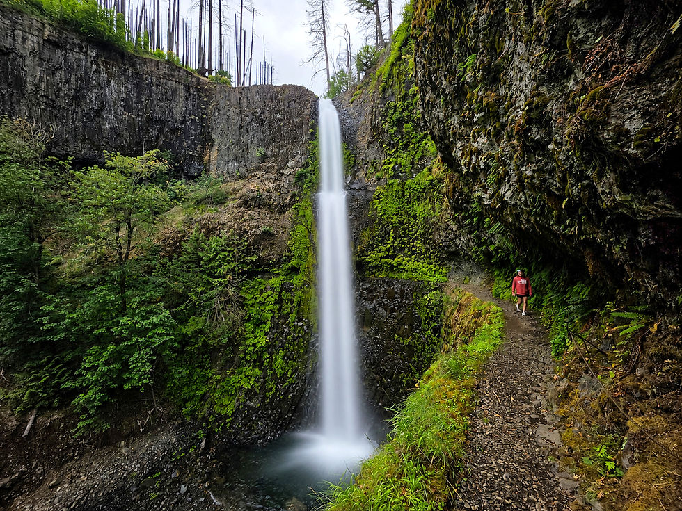
At approximately 1.1 miles, the trail leads directly beside Fairy Falls, a delicate 20-foot fan waterfall cascading over a moss-covered basalt wall along an unnamed tributary of Wahkeena Creek. While modest in height, Fairy Falls is widely considered one of the most photogenic waterfalls in the Columbia River Gorge thanks to its emerald-green backdrop and graceful ribbons of water.

Beyond Fairy Falls, the climb gradually eases as the trail passes through a predominantly Douglas fir forest. Around 1.8 miles, hikers reach the highest point of the loop. Occasional openings in the trees provide distant views of the Columbia River, while scattered blackened trunks and recovering vegetation serve as reminders of the 2017 Eagle Creek Fire, which burned thousands of acres throughout the Gorge. Fortunately, much of this section continues to recover, with young trees, ferns, and wildflowers steadily reclaiming the forest floor.

As the trail descends toward Multnomah Creek, it joins the Larch Mountain Trail around 2.7 miles into the hike. Shortly afterward, hikers pass above Ecola Falls, a graceful 55-foot cascade hidden within dense foliage along Multnomah Creek. Although partially obscured for much of the year, careful observers can usually catch glimpses of the waterfall's crest through breaks in the vegetation.

A series of additional switchbacks soon leads to Wiesendanger Falls, a beautiful 50-foot plunge waterfall dropping through a narrow moss-covered basalt cleft. The falls honor Albert Wiesendanger, a longtime U.S. Forest Service employee whose efforts helped expand recreation opportunities throughout Oregon's national forests during the early twentieth century. Despite its impressive setting, Wiesendanger Falls remains one of the least-visited named waterfalls on the loop.


Just beyond lies Dutchman Falls, where Multnomah Creek tumbles over a pair of basalt ledges in a picturesque 30-foot two-tier cascade. While smaller than its neighboring waterfalls, Dutchman Falls adds yet another scenic stop to one of Oregon's finest waterfall hikes.

A short distance later, the trail reaches the Top of the Falls Trail, a paved spur leading to an overlook perched at the brink of Multnomah Falls. Before reaching the overlook, the creek squeezes over a smaller basalt ledge, hinting at the dramatic drop only a few yards downstream. The spacious viewing area above the falls also makes an excellent place to stop for lunch while enjoying views over the Columbia River Gorge. This is also where the solitude of the upper trail begins to fade, as visitors arriving from the Multnomah Falls parking area become increasingly common.

After returning to the main trail, hikers descend 11 paved switchbacks toward the base of Multnomah Falls. Along the way, several overlooks provide increasingly dramatic perspectives of the waterfall before the trail reaches the famous Benson Bridge, built in 1914 and suspended between the upper and lower cascades.

The scene at the base is often a dramatic contrast to the peaceful upper portions of the hike. As one of Oregon's most visited natural attractions, Multnomah Falls draws more than two million visitors each year, and the viewing area surrounding Benson Bridge is frequently crowded.

The crowds, however, are easy to understand. At 620 feet, Multnomah Falls is the tallest waterfall in Oregon, dropping 542 feet in its upper plunge before cascading another 78 feet to its lower tier. The waterfall is named after the Multnomah people, a Chinookan-speaking tribe whose villages once lined the lower Columbia River near present-day Sauvie Island and the Portland Basin. According to a traditional Native story, the waterfall was created when a young woman sacrificed herself from the cliffs above to save her people during a devastating epidemic, forever tying Multnomah Falls to the cultural heritage of the Columbia River Gorge.
After soaking in the views, the hike passes the historic Multnomah Falls Lodge and Visitor Center before following the Historic Columbia River Highway for a short distance. The well-marked Return Trail then climbs gently back toward Wahkeena Falls, completing one of the finest waterfall hikes in Oregon and one of the most rewarding loops in the Columbia River Gorge.




Comments